Westmount Creek Watershed
Summary
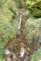
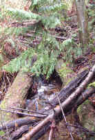
Characteristics
- Fifteenth largest watershed in West Vancouver
- Originates on municipal land on the south flank of Hollyburn Ridge. Flows down forested mountainside, crossing Cypress Bowl Road several times. Enters the urban area in a preserved riparian strip between Deer Ridge and Deer Ridge West. Crosses under the Upper Levels highway and Benbow Road, Westmount Place, Thompson Crescent, Mathers Avenue, past Dickinson Crescent and under Marine Drive. Discharges to Burrard Inlet at West Bay near Radcliffe Avenue
Watershed Use
- Residential
- Park: Benbow Park, Deer Ridge Park
- Recreational: hiking trails, mountain biking trails
- Fish:
Concerns
- Obstructions or barriers to migrating fish at culverts at the railway crossing, several road and driveway culverts to the highway, culverts at highway and on Cypress Bowl Road
- Water quality altered through proximity to urban development and storm drain discharge and the potential for sewer lines breakages
- Current development and future development in upper watershed and associated problems, including an increase in imperviousness, the loss of wetlands and tributaries, the construction of storm drain network resulting in altered water quality and quantity, encroachment into riparian zones, tributary channelization or loss, bank alteration and increased erosion into creek
Watershed Projects
- 500 coho released from the Nelson Creek Hatchery, 2000
- Headwaters studied as part of environmental feasibility study for proposed Hollyburn Golf Course, 1989
- Bank stabilization completed, year unknown (FISS)
- Biophysical surveys, year unknown (FISS)
Prepared by Elizabeth Hardy, March 2003