Characteristics
- Maplewood Creek is part of the Seymour River system
- Originates above Mount Seymour Parkway. Groundwater from upslope terraces discharges through several springs and seepages and supports a network of wetlands that form the headwaters.
- Status: Endangered – due to riparian removal, urbanization, culverting and degraded water quality.
History
- Before mid-1800’s -North Vancouver District was inhabited by Coast Salish peoples.
- 1860’s - First significant non-native settlement began.
- Late 1800’s to early 1900’s – Trees over 90 m high and 11 m in circumference were logged. Windridge area extensively logged around 1910.
- 1865 – Hugh Barr purchases first land east of Seymor River beginning first European settlement.
- 1930 - Construction of the Dollarton Highway encourages further settlement of the Maplewood neighbourhood.
- 1950s - Port oriented industry commenced with the introduction of the first chemical plant in Maplewood.
- 1987 – Ammonia runoff from duck pond results in high mortality of juvenile coho.
- 1990 – First return of chum (15) following enhancement efforts.
Watershed Use
- Fish – chum and coho salmon. Documented spawning south of Seymour Parkway. Unconfirmed sightings north of Parkway.
- Wildlife: bear, bobcat, coyote, raccoon and red fox have been recently seen by residents. Also, deer, moles, shrews, marten, weasel, mink, turtles, lizards, snakes are believed to inhabit area.
- Diverse bird population: 80 species (Tera).
- Vegetation: Coastal Western Hemlock Zone
- Maplewood Farm, District of North Vancouver
- Residential
- Maplewood Community School
- Seymour River floodplain
Concerns
- Stream has been classified as endangered due to impacts (FRAP).
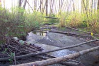
- Significant loss of riparian vegetation along more than 50% of the fish frequented length of the stream (FRAP). Loss of vegetation due to development and removal by land owners.
- Water quality – Significant problems including problems with ammonia, sediments from erosion and development near the creek (FRAP), and contaminants from stormwater and spills into storm drains.3 storm drains discharge into creek. High nutrient run-off from equestrian centre, duck pond, and Maplewood Farm.
- Urbanization in the watershed has significantly affected the stream basin (FRAP)
- Channelization, armourization, or dyking of over 50% of the fish frequented length of the stream (FRAP)
- Aquatic system considered highly valuable and highly sensitive to development (Triton).
- Creek was diverted and recreated to build Mount Seymour Parkway.
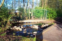
- Groundwater discharge at the area of Hogan’s Pools supports a wetland and the Maplewood stream system and associated fishery which are highly sensitive to development (Triton, 1993).
Key Interest Groups/Government Bodies
- Municipal Gov’t: District of North Vancouver (DNV); District Parks Department; Maplewood Farm.
- Regional: GVRD (regional parks, sewers and air quality); GVWD
- Provincial Gov’t: Ministry of Transportation and Highways; Ministry of Environment, Lands and Parks; Burrard Inlet Environmental Action Program
- Federal Gov’t: Department of Fisheries and Oceans; Environment Canada; Transport Canada
- Local NGO’s: North Shore Streamkeepers; North Shore Fish and Game Club; Pacific Streamkeepers Federation; Maplewood Community Association; Wild Bird Trust of BC
- Tsleil’waututh Nation - Burrard Inlet Band
- Vancouver Port Corporation
- BC Rail
- Various industries located near mouth
- BC Hydro
- Private Land Owners and Occupants
- Wild Bird Trust of BC
- School District 44: Maplewood Community School
- North (Shore/Vancouver) Historical Society
Watershed Projects
- 82/85 – DFO released coho at Mount Seymour Parkway.
- 1987 – DFO program to enhance coho and chum populations initiated. DFO put an incubation box for chum at Mount Seymour Parkway.
- 91/92 - Maplewood Community School students – involved in a salmon incubation box program. Released salmon north of parkway.
- 1997 – GIS mapping - District of North Vancouver
- YEAR? - Local residents channelized creek north of Parkway and enhanced overhead cover.
- YEAR? - Maplewood Farm – Salmonid Enhancement Project
Recommendations and Suggested Actions
- Protect the highly sensitive aquatic habitat of Hogan’s Pools as park (Triton, 1993).
- Maintain the continuous native riparian conduit from Seymour River headwaters to Hogan’s Pool area provides wildlife habitat and corridors (Triton).
- Maintenance of habitat corridors requires cooperative planning with other property owners between Hogan’s Pools and the Upper Seymour watershed (Triton).
Available Sources of Information
Map: TRIM/UTM - BC Ministry of Environment, Lands and Parks
Map: District of North Vancouver
District of North Vancouver. The Maplewood Official Community Plan.
Planning Dept. of the District of North Vancouver. (Jan. 1977). The Natural Environment of the Maplewood Estuaries. Based on research by Environment Canada.
Precision Identification Biological Consultants. (1997). Prepared for Fraser River Action Plan, Fisheries and Oceans Branch. Wild, Threatened, Endangered and Lost Streams of the Lower Fraser Valley: Summary Report. Lower Fraser Valley Stream Review, Vol. 3.
Renshaw, Timothy. December 12, 1990. "North Shore fish battle to survive in a polluted urban environment". in the North Shore News.
Tera Consultants Limited. (April 1980). Terrain Reconnaissance in the Maplewood Planning Area of the District of North Vancouver. Prepared for the District of North Vancouver.
Tera Planning Ltd. (January 1992). Environmental Assessment of the Windridge Area, North Vancouver. Prepared for the District of North Vancouver Planning Department.
Triton Environmental Consultants. (1993). Environmental Evaluation: Hogan’s Pools.