Characteristics
- Mackay Creek originates at about 2800 ft. near the top on the southwest slope of Grouse Mountain and flows through 2nd growth coniferous rainforests. Further down the mountain, Mackay flows through residential areas in the District of North Vancouver. Below the Upper Levels Hwy., Mackay enters the City of North Vancouver, and then flows under Marine Drive and back into the District of North Vancouver where it flows through the commercial area into McKay Park, and under the BC Rail tracks through a drainage ditch and a culvert into Burrard Inlet.
- 29% impervious area in watershed; 54% RFI (GVRD, 1999).
- Maximum tidal ranges in the area are 16 feet with a mean tidal range of about 14 feet (Haggard, 1978).
- Trend = Stable
- Status: Endangered – due to impacts of urbanization and the loss of the estuary.
- 25 year flood event (Kerr Wood Leidal Associates, 1982)
- Baseflow = 0.04 to 0.09 m3/s per km2 in winter and 0.03 to 0.06 m3/s per km 2 in summer (Tera, 1980).
History
- Before mid-1800’s -North Vancouver District was inhabited by Coast Salish peoples
- 1860’s - The first significant non-native settlement began.
- Late 1800’s to early 1900’s – Logging (some trees 90 m high & 11 m in circumference)
- Mid-80’s – Coho escapement reached over 100
- 1986 – Firm fined $1,500 for dumping driveway sealant in McKay Creek
- November 23, 1995 – 7,000 cubic metre debris flow above the BC Hydro right-of-way. The District responded with channel restoration, technical investigations and mitigation measures (debris basin and culvert upgrading) at a cost of $2 million
- 1990 – Average coho escapement was 200
- 1996 – McKay Creek was ‘adopted’ by local residents –streamkeepers
Watershed Use
- Anadromous fish (coho, chum, pink, cutthroat and steelhead) have access up to falls located near Montroyal Blvd. Spawning occurs in the lower 2 km of the creek. Dolly Varden and Rainbow trout are found above Upper Level Highway.
- The creek and surrounding plants provide wildlife habitat and travel corridor
- Vegetation: Coastal Western Hemlock Zone
- Residential
- Parks: Mackay Creek, Heywood, and Murdo Fraser Parks
- Recreation: walking and hiking trails
- Grouse Mountain Resort parking lot; Grouse Mountain ski resort
- Old gravel pit.
- GVRD water mains cross McKay; Hydrometric station; Power line
- Commercial industry in lower reaches.
Concerns
- Classified as endangered due to the impacts of urbanization (riparian removal, channelization, poor water quality, and high effective impermeable area). The estuary has been lost (DFO, 1998)
- Significant water quality problems (FRAP):
- Adversely affected by commercial industrial plants in lower areas and by heavy residential development its entire length (Renshaw, 1990).
- Grouse Mountain ski area activities such as snowmaking may affect downstream water supply and quality (DFO, 1998).
- 74 storm drains discharge into Mackay. Concern over toxic levels of heavy metals and sedimentation. Significant storm runoff in lower watershed from extremely busy roads such as Marine Drive needs to be addressed.
- The watershed is heavily developed as residential up to the Grouse Mountain gondola area. Intensive development increases the risk of spills, stormwater impacts on water quality and quantity, riparian removal, unauthorized instream works and bank alterations, and channel modifications (DFO, 1998)
- Past developmental practices allowed residential development very close to the creek leaving large parts of the watershed in the hands of private property owners and resulting in loss of riparian vegetation and increased erosion
- Urbanization in the watershed has significantly affected the stream basin (FRAP)
- Effective impervious area covering approximately 10% or more of stream’s watershed (FRAP)
- There are recurrent development applications which propose to divert, dyke, infill or modify the floodplain or mouth (DFO, 1998)
- Significant loss of riparian vegetation along more than 50% of the fish frequented length of the stream (FRAP)
- Channelization, armourization, or dyking of over 50% of the fish frequented length of the stream (FRAP)
- Concern over cumulative impacts (FRAP)
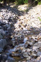
- Bank and slope stability leading to erosion and flooding. Progressive sedimentation and plugging of trash racks at culvert inlets under flood flow conditions in tributary channels in upper reaches (Kerr Wood Leidal Associates, 1982). Clearing of vegetation upstream is causing erosion and undercutting of banks (Haggard, 1978)
- Debris flow or debris flood risk rated very high (1:20); sufficient to warrant mitigative actions or further study (Kerr Wood Leidal Associates, 1999)
- Damming in several areas (especially in the Mt. Royal Blvd. area) blocks fish passage (Haggard, 1978)
- The ski area is a watershed management concern (Kerr Wood Leidal Associates, 1999). Grouse Mountain Resorts operates a ski resort within the headwaters and clearing has impacted surface drainage. No comprehensive management plan exists
- The large debris basin constructed in the headwater area of the east branch affects the downstream migration of gravels, woody debris and nutrients
- There has been some unauthorized netting of fish by aboriginal groups. Currently, there is no agreement governing use of anadromous species
- The creek runs through 2 municipalities but management of the creek has not been coordinated
- The fish populations and species diversity are not consistent with the amount of habitat
- Erosion at Handsworth School
Key Interest Groups/Government Bodies
- Municipal Gov’t: District of North Vancouver (DNV); District Parks Department;City of North Vancouver (CNV)
- Regional: GVRD (regional parks, sewers and air quality); GVWD
- Provincial Gov’t: Ministry of Transportation and Highways; Ministry of Environment, Lands and Parks; Burrard Inlet Environmental Action Program
- Federal Gov’t: Department of Fisheries and Oceans; Environment Canada; Transport Canada
- Local NGO’s: North Shore Streamkeepers; North Shore Fish and Game Club
- Grouse Mountain ski resort
- BC Rail; BC Hydro
- Vancouver Port Corporation
- Seaspan
- Various commercial and light industries located near mouth
- Edgemont Community Association
- Pemberton Heights Community Association
- Sunset Gardens Neighbourhood Association
- School District 44: Mont Royal, Handsworth, Canyon Heights and Hamilton Schools
- North (Shore/Vancouver) Historical Society
Watershed Projects
- Incubation box for coho located at Brookridge Dr., a net pen at Canyon Blvd.
- 1981 – Incubation box for coho below Ridgewood Drive - ? Are this and above the same enhancement?
- 1982 - Fish ladder - south of Ridgewood Drive – North Shore Fish and Game Club
- Enhancement of Emsley Creek.
- Some storm drain marking has been done throughout the watershed.
- North Shore Fish and Game Club runs Wilderness Watch, a type of neighbourhood watch program for wildlife and operates a hatchery on McKay Creek.
- 91-92 - District 44 school students released coho fry at Heywood Park, Ridgewood Drive, Prospect Ave. and 14th St.
- Restored habitat degraded by 1995 debris flow by constructing a debris basin, riprapping and planting.
- 1997 – GIS mapping - District of North Vancouver
- Annual Mackay Creek Clean-up.
Recommendations and Suggested Actions
- The District of North Vancouver should be encouraged to maintain, and possibly expand, its comprehensive Environmental and Preservation Bylaw which protects, preserves, and conserves natural settings and ecological systems of trees, watercourses, soils and lands (DFO, 1998).
- The City of North Vancouver should be encouraged to develop similar provisions that would give consistent level of protection throughout the watershed (DFO, 1998).
- Pink and chum smolt releases could be undertaken to enhance runs (coho is already being released into the stream) (DFO, 1998).
- Fishways at Montroyal Blvd. and Marigold Ave. could be installed to improve fish passage (DFO, 1998).
- In addition to enhancement efforts by volunteers, additional stewardship activities are required which focus on preventing spills and reducing stormwater impacts on stream water quality, protecting and restoring riparian habitat, land owner contact, improving public awareness, preventing stream encroachments, and advocacy (DFO, 1998).
- Stormwater and debris management plans are urgently required for this watershed. Future stormwater infrastructure especially needs to be developed within the framework of a management plan (DFO, 1998).
- The restoration of an estuary area would provide a resting and feeding area for fish, as well as habitat for other wildlife (DFO, 1998).
- Developing off-channel habitat can help protect fish during summer and winter extreme flows (DFO, 1998).
- Recreational access throughout the system needs to be carefully managed (DFO, 1998).
- Redevelopment proposals in this watershed should be encouraged to increase setbacks from top of bank, modify the development footprint, or restrict access to the watercourse (DFO, 1998).
- Enhancement proposals include side channel development for both Mackay and Emsley, realignment of the river, re-creation of the estuary, and storm drain marking (DFO, 1998).
- Culverts and other structures should be designed to allow passage of adult salmon under a broad range of discharges (Northwest Hydraulic Consultants, Ltd., 1991).
- A minimum 50’ (optimum 200’) wide strip on both sides of the water’s immediate edge shall be maintained. (Desirable the 2nd St. area to preserve a minimum 100’ strip due to the creek’s unstable or meandering nature in this area) (Haggard, 1978).
- The District should design in harmony with the creek corridor and all developments should be harmonious with native existing creek environment including the use of native plants (Haggard, 1978).
- The District has a unique opportunity to develop an indigenous industrial park at the northwest corner of Lloyd Ave. and Welch St. where there is a low area pond (Haggard, 1978).
- Convert inactive gravel pit to small debris basin. Further study recommended (Kerr Wood Leidal Associates, 1999).
- Require Grouse Mountain Resorts to develop a water management plan for their snowmaking system to minimize downstream impacts (Kerr Wood Leidal Associates, 1999).
- Advise District Parks, Grouse Mountain Resorts and others to obtain engineering input on construction of hiking trail creek crossings (Kerr Wood Leidal Associates, 1999).
- Consult with Grouse Mountain Resorts to determine the debris flow problem, magnitude and area of impact and develop a mitigative strategy (Kerr Wood Leidal Associates, 1999).
Good Things
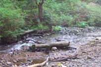
- Much of the mid-reach is in a ravine which has a good riparian zone (DFO, 1998).
Available Sources of Information
Maps: TRIM/UTM 92G035 - BC Ministry of Environment, Lands and Parks
Map: District of North Vancouver
Bohn, Glenn. (Sept. 3, 1998). "Owners of Creekside Property Let Walkers Cross Their Land". Vancouver Sun.
Department of Fisheries and Oceans Canada (1998) "Wild, Threatened, Endangered and Lost Streams of the Lower Fraser Valley: Summary Report 1997". Prepared by Precision Identification Biological Consultants, Vancouver, BC.
Emsley Creek (1985). Creek Naming Documents. North Vancouver Archives.
Harry Lee Haggard Landscape Architect (March 1978). Mackay Park Study (Creek). Prepared for the District of North Vancouver Planning Dept.
Kerr Wood Leidal Associates Ltd. (1999) "Overview Study of Debris Flow Hazards". Prepared for the District of North Vancouver.
Kerr Wood Leidal Associates Ltd. (July 1982). "Report on Creek Systems and Stormwater Control". District of North Vancouver.
Kerr Wood Leidal Associates Ltd. (1982). District of North Vancouver: Report on Mackay Creek (Working Paper No. 5). Prepared for the Corporation of North Vancouver.
Morton, Brian. (Nov. 9, 1996). "North Vancouver Residents Fear Barrier Won’t Hold Raging Creek". Vancouver Sun.
Mudry, Brent. (June 5, 1996). "Lawsuits Flood District". North Shore News.
Noble, Ian. (Aug. 2, 1996). "Creek Debris Basin Project Approved". North Shore News.
Northwest Hydraulic Consultants Ltd. (1991). Replacement of Timber Bridges at McKay ck. (Mi 1.1), Red Rock Ck.(Mi 449.1 and Cale Ck.(Mi 452.7). B.C. Rail Engineering Dept.
Precision Identification Biological Consultants. (1997). Prepared for Fraser River Action Plan, Fisheries and Oceans Branch. Wild, Threatened, Endangered and Lost Streams of the Lower Fraser Valley: Summary Report. Lower Fraser Valley Stream Review, Vols. 1 & 3.
Renshaw, Timothy. December 12, 1990. "North Shore fish battle to survive in a polluted urban environment". in the North Shore News.
Yip, Jeffrey and Truelove, Paul. (June-Aug. 1974). A Stream Assessment Survey of the Mosquito, Mackay and Hastings Creeks: A Study of Fish Habitats.