Rodgers Creek Watershed
Summary
Characteristics:
- Fifth largest watershed in West Vancouver
- Originates on southern slopes of Hollyburn Mountain in Cypress Provincial Park as an ephemeral creek in the cross-country ski area. Rodgers Creek flows down forested mountainside, passing under the Cypress Bowl Road several times before it reaches urban development and the Upper Levels Highway. The creek continues between 28th and 29th Streets, under Marine Drive, a BC Rail overpass and Belleview Avenue before discharging to Burrard Inlet.
Watershed use:
- Residential
- Park: Cypress Provincial Park
- Recreation: Hollyburn Ridge cross country ski area operated by Cypress Bowl Recreations in the headwater, Hollyburn municipal cabins, and Trans Canada Trail and other hiking trails, mountain biking
- Fish: coho salmon to Marine Drive culvert 0.4 km from mouth, cutthroat trout
Concerns:
- Classified as endangered by Fisheries and Oceans Canada due to the effects of urbanization (channelization, culverts, riparian loss, poor water quality)
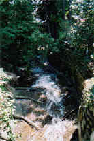
- Fish barriers or potential barriers include creek channelization between Belleview Avenue and ocean, the culvert under Marine Drive, the concrete waterfall at Nelson Avenue, the cascade at Rosebery Avenue, and the concrete wall and series of log weirs upstream of Rosebery Avenue
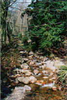
- Lack of riparian vegetation in lower reaches
- Lack of woody debris through good fish habitat areas
- Water quality intermittently effected by urban activities
- Future residential or commercial development in upper watershed and associated problems, including an increase in imperviousness, a loss of wetlands and tributaries, construction of storm drain network resulting in altered water quality and quantity, encroachment into riparian zones, creek channelization and bank alteration and increased erosion into the creek
Watershed Projects:
- 2001 proposal to install fish ladder at Marine Drive, baffles installed in the culvert under Belleview Avenue in 1998
- Water quality samples taken in urban area, 1999
- Habitat assessment, vegetation and wildlife studies, water quality samples collected in the upper watershed, 1996, 1997 and 1998
- Habitat surveys conducted in urban area, 1995 and 1997
- Stocked with coho fry from 1980 to 1983, 1987 to 1992, 2000 and chum from 1984 to 1986