Characteristics:
- Twelfth largest watershed in West Vancouver
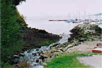
- Discharges into Burrard Inlet at Eagle Harbour
- Originates near Eagle Lake
- Bordered by Nelson Creek, Cypress Creek and Wood Creek watersheds
- Main tributary is Wood Creek at 140 metres from mouth
- Twenty-seven percent of watershed lies between Upper Levels highway and Marine Drive
History:
- Named for the large number of eagles which nested in this area
- Proposed sawmill at the mouth of Eagle Creek was never completed and later the foundations were used for a fish cannery which burned in June 1910
- Keith Road was constructed through West Vancouver to Eagle Harbour in 1892
Watershed Use:
- Residential: approximately 140 houses in the watershed
- Automobile and train transportation
- Recreation:
- hiking, Trans Canada Trail, and other trails
- mountain biking
- Fish: chum salmon, coho salmon to Marine Drive, cutthroat trout
- Wildlife: diverse populations of mammal, bird and amphibians (i.e. otter, mink, black bear, coyote, Great Blue Herron, Kingfisher, American Dipper tailed frog, Western Red Backed Salamander, Ensatina)
Concerns:
- Classified as threatened by Fisheries and Oceans Canada due to impact of urbanization
- Infill development and future development in the upper watershed and associated problems, including:
- Increase in imperviousness
- Loss of wetlands and tributaries
- Construction of storm drain network resulting in altered water quality and quantity
- Encroachment into riparian zones
- Creek channelization, bank alteration
- Increased erosion into creek
- Water quality:
- siltation potential from BC Ferries rock sorting platform adjacent to riparian zone, between upper Westport Road and Upper Levels Highway
- altered through proximity to urban development and storm drain discharge
- potential sewage leaks: two sewage lift stations in the watershed (on Eagle Harbour Road and Gallagher Place), and at least two sewer line crossings of the creek
- potential for contamination in the harbour at the mouth of the creek from Eagle Harbour Yacht Club boats
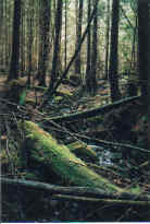
- Morphology:
- channelization through urban areas
- culverted near mouth, under Marine Drive and Daffodil Lane and under several private driveways, and extensive culverting (550+ m) under Westhaven Wynd, Upper Levels highway and Westport Road.
- Damming of Eagle Lake may have cut off high water overflow contribution to Eagle Creek
Key Interest Groups:
- West Vancouver Streamkeepers
- Federal: Department of Fisheries and Oceans
- Provincial: Ministry of Environment, Lands and Parks; Ministry of Transportation and Highways
- District of West Vancouver, District Parks Department
- Community associations
- Eagle Harbour Yacht Club
- BC Rail
Watershed Projects:
- Digitized map of urban watershed including storm drain network, SHIM website, 2001
- Turnbuckle-style baffles installed in culvert at mouth of creek to improve fish access to Marine Drive and rock steps at mouth reworked, Coast Environmental Services, 2000
- Stocked with coho and chum fry, West Vancouver Streamkeepers, from 1991
- Construction of diversion pipes from Eagle Lake to augment low summer flow, not yet in use, District of West Vancouver, 1999
- Water quality samples taken, North Shore Streamkeepers, 1999
- Spawner surveys, West Vancouver Streamkeepers, 1997 onwards
- Stream survey, West Vancouver Streamkeepers, 1997
- Series of drops and pools created at the mouth to improve access for fish, 1979
Available Sources of Information:
Maps: TRIM/UTM 92G034
Web Sites:
- http://www.pskf.ca The Pacific Streamkeepers Federation
- www.bcfisheries.gov.bc.ca/fishinv/fiss.html Fisheries Information Summary System (FISS)
- www.bcfisheries.gov.bc.ca/fishinv/index.html includes FISS, Survey Data, Base Maps, Methods
- http://www-heb.pac.dfo-mpo.gc.ca/English/maps.htm includes Fish Wizard, Fisheries Project Registry, SHIM Data with Orthophotos, Wild Threatened, Endangered and Lost Streams of the Lower Fraser Valley
- www.shim.bc.ca Sensitive Habitat Information and Summary
- www.elp.gov.bc.ca:8000/pls/wtrwhse/water_licences.input water licence information
Reports:
- District of West Vancouver Drainage Survey. Dayton and Knight Ltd., 1973
- Task Force Inquiry into Drainage Policies and Problems. District of West Vancouver, 1977.
- Creeks in West Vancouver. Hugh Johnston? 1990
- Lower Fraser Valley Stream Review, Vol. 1. Fisheries and Oceans Canada. Fraser River Action Plan, 1999
- Wild, Threatened, Endangered and Lost Streams of the Lower Fraser Valley, Summary Report. Fisheries and Oceans Canada. Fraser River Action Plan, 1997
- Habitat Compensation for 5674 Westport Road Development, West Vancouver, B.C. Coast River Environmental Services Ltd, 2000
- North Shore Streams- Nutrient Impacts. North Shore Streamkeepers, 1999
- Fish Habitat Inventory and Information Program, Stream Information Summary. Department of Fisheries and Oceans, 1989