Characteristics:
- Largest watershed in West Vancouver
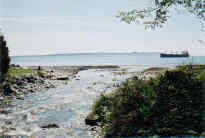
- Discharges into Burrard Inlet near Pilot Cove
- Originates on east Black Mountain plateau, Mount Strachan and Hollyburn Mountain in Cypress Provincial Park
- Bordered by Willow Creek, Wood Creek, Eagle Creek and Nelson Creek on the west and Disbrow Creek, Montizambert Creek, Strachan Creek and Nickey Creek in the headwaters and Marr Creek, Westmount Creek, Pipe Creek, Rodgers Creek, Marr Creek and Capilano River watersheds to the east
- Numerous small lakes and wetlands occur in the Cypress Creek watershed, including those in Cypress Bowl (Yew Lake) and on the east side of Black Mountain
- Tributaries: over 25 in the upper watershed
- Slope is about 12% above B. C. Rail overpass, and about 3% below
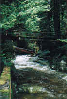
- Potential spawning habitat to impassable falls (10 metres) approximately 1.6 kilometres upstream from mouth
- Total impervious area over entire watershed is 2%
History:
- Site of unsuccessful logging camp established by Sewell Moody in 1870, attempted to float yellow cedar (Cypress) down the creek
- Area near mouth settled in 1886 by Walter Irwin, lightkeeper at Point Atkinson
- Logging box flume from Cypress Creek at 366 m elevation to Eyremount Mill at 304 m elevation in late 1800’s
- Francis Caulfeild installed water supply system from Caulfeilds Creek in 1909, expanded it to include an intake above the falls on Cypress Creek in 1910, municipality took over system in 1923
- Supplied water to Caulfeild area from an intake at the 210 m elevation on Cypress Creek, to a pool on District Lot 1240 at 88 m elevation, via 12 cm pipe
- Cypress Bowl set aside as a provincial park in 1944 in response to opposition over logging on Hollyburn Ridge and in the Cypress Creek valley, to preserve hiking and skiing recreation
- Skiing and cabin area on Hollyburn Ridge since 1920’s. Logging to clear for ski development on Mt. Strachan and Black Mountain from 1966 to 1969. Initial ski facilities built 1971/1972
- Annual maintenance to creek in 1984 involved pushing aside bed deposits at mouth in spring or early summer, in addition to excavating creek bed, building up banks and adding rip-rap on an as needed basis
Watershed use:
- Residential
- Recreational:
- hiking- Trans Canada Trail, other trails
- mountain biking
- Cypress Bowl Recreations ski development
- Commercial:
- Cypress Bowl Recreations ski development in the upper watershed
- Cypress Park shopping area on Marine Drive
- Parks: Cypress Falls Park, Cypress Bowl Provincial Park
- Water Supply:
- West Vancouver Laboratories, 2 water licences, 60,000+ gal/day
- Cypress Bowl Recreations, 4 water licence applications, 126,000+ gal/day
- Fish: coho and chinook to Keith Road, chum, cutthroat, steelhead, rainbow trout in Yew Lake
- Wildlife: diverse populations of mammals, birds and amphibians inhabit the watershed (ie. black bear, coyote, Coastal Black-tailed deer, mountain goat, smaller mammals, 82 species of birds)
- Cypress Bowl Road, TransCanada Highway, Marine Drive, B.C. Hydro, BC rail
Concerns:
- Classified as endangered due to development in the lower watershed, dredging of lower reaches, and development for recreation in the upper watershed
- Morphology:
- channel dredging below Marine Drive has simplified the stream channel
- Water Quality:
- altered through proximity to urban development and storm drain discharges
- potential for sewer line breakages
- Water supply:
- possible future diversion of water from a Cypress Creek tributary to Eagle Lake to supplement the municipal water supply and the potential combined effect of water withdrawal on creek flows
- Flooding:
- footbridge between Erwin Drive and Ross Crescent washed away in 1975
- flooding below Marine Drive in 1983
- Future residential and commercial development in upper watershed and associated problems, including:
- increase in imperviousness
- loss of wetlands and tributaries
- construction of storm drain network resulting in altered water quality and quantity
- creek channelization, bank, alteration
- increased erosion into creek
Key Interest Groups:
- Federal: Department of Fisheries and Oceans
- Provincial: Ministry of Transportation and Highways; Ministry of Environment Lands and Parks
- District of West Vancouver, District Parks Department
- West Vancouver Streamkeepers
- Homeowners association
- British Pacific Properties
- Cypress Bowl Recreations
- Hollyburn cabin owners
- BC Rail
- Trans Canada Trail
- Mountain bike association
Watershed Projects:
- Water quality samples taken, North Shore Streamkeepers, 1999
- Drainage system inventory in headwaters, McElhanney Consulting Services Ltd., 1998
- Vegetation and wildlife studies in headwaters, Talisman Land Resource Consultants, 1996
- Rainbow trout stocked in Yew Lake in 1985
- Incubation box for coho salmon from 1978 to 1979
Available Sources of Information:
Maps: TRIM/UTM 92G034
Web Sites:
- http://www.pskf.ca The Pacific Streamkeepers Federation
- www.bcfisheries.gov.bc.ca/fishinv/fiss.html Fisheries Information Summary System (FISS)
- www.bcfisheries.gov.bc.ca/fishinv/index.html includes FISS, Survey Data, Base Maps, Methods
- http://www-heb.pac.dfo-mpo.gc.ca/English/maps.htm includes Fish Wizard, Fisheries Project Registry, SHIM Data with Orthophotos, Wild Threatened, Endangered and Lost Streams of the Lower Fraser Valley
- www.shim.bc.ca Sensitive Habitat Information and Summary
- www.elp.gov.bc.ca:8000/pls/wtrwhse/water_licences.input water licence information
Reports:
- District of West Vancouver Drainage Survey. Dayton and Knight Ltd., 1973
- Cypress Bowl Recreations’ Master Concept Plan to Enhance Services, Facilities and Recreational Opportunities for Visitors to Cypress Provincial Park: Environmental Assessment. Talisman Land Resource Consultants, 1992
- Report to the District of West Vancouver on the Cypress Creek Flooding. Dayton and Knight, 1984
- Assessment of Current and Future GVS&DD Area Watershed and Catchment Conditions. Greater Vancouver Sewerage and Drainage District Liquid Waste Management Plan, 1999
- West Vancouver Water Supply. H. B. Muckleston, 1930
- Water Supply Investigations, Report on Eagle Lake. D. W. Hodsdon, 1926
- Creeks in West Vancouver. Hugh Johnston?, 1990
- A History of West Vancouver. Waldon, P. S., 1947
- A Place of Excellence: A Chronicle of West Vancouver, 1912-1987. Bruce Ramsey, 1986
- Report to Municipal Council. West Vancouver, Select Committee on Future Recreation Use of Hollyburn Ridge, 1976
- Report of the Cypress Park Special Planning Commission/ Bryan Williams (Special Commissioner). Cypress Park Special Planning Commission, 1995
- Cypress Provincial Park Master Plan: Draft. B. C. Parks, 1995
- Lower Fraser Valley Stream Review, Vol. 1. Fisheries and Oceans Canada, Fraser River Action Plan, 1999
- Wild, Threatened, Endangered and Lost Streams of the Lower Fraser Valley, Summary Report. Fisheries and Oceans Canada, Fraser River Action Plan, 1997
- North Shore Streams: Nutrient Impacts. North Shore Streamkeepers, 1999
- Report to the Ministry of Environment, Lands and Parks, Parks Division for Cypress Provincial Park Hydrology Study and Master Drainage Plan: Final Report. McElhanney Consulting Services Ltd., 1998
- CRA Master Plan, 1996. Environmental Planning Assessment. Talisman Land Resource Consultants, 1997