Marr Creek Watershed
Profile
Characteristics:
- Eighth largest watershed in West Vancouver
- Bordered by Rodgers Creek watershed to the west and MacDonald watershed to the east in West Vancouver, BC
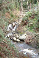
- Originates south of Hollyburn Ridge in Cypress Provincial Park as two branches
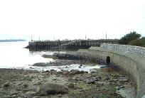
- Discharges into Burrard Inlet east of the Dundarave Pier
- First Lake at Hollyburn Lodge and Fourth Lake are in the headwaters
- Several small and ephemeral tributaries, several small lakes and wetlands in headwaters
- Good fish habitat throughout upper creek, at First Lake, downstream of lake 5% gradient with abundant cover and spawning gravel, mid watershed gradient 28% but some pools and cover for fish
- Headwaters acidic with elevated coliform, chromium, dissolved aluminum [5]
- Tributary to creek crosses water/sewer link to Cypress Provincial Park
- Coastal Western Hemlock biogeoclimatic zone below 900 m, Mountain Hemlock Zone above 900 m
- Total impervious area 17% [8]
History:
- Named for George Marr who operated a logging camp and booming ground at the mouth of the creek from 1903 to 1909. His cabin was at 27th Street and Palmerston
- Hikers and skiers arrived in upper watershed in the 1920’s. Cabins were built through to the 1940’s. First Lake Lodge was built in 1926. The provincial government set aside Cypress Bowl as a park reserve in 1944, and designated it as a Class A Provincial Park in 1975
- The railway laid tracks in 1913 and started passenger service in 1914. The Western terminus was at 25th Street. Service was extended to Horseshoe Bay in 1914 and discontinued in 1928 [7]
- Marr Creek flooded in 1955, caused by natural forces aggravated by deforestation and upstream housing construction [6]
Watershed Use:
- Residential:
- Commercial: Dundarave Village shopping area
- Schools: Collingwood Elementary, Irwin Park Elementary
- Park: Dundarave Park, Cypress Provincial Park
- Recreational: Hollyburn cross-country ski area, Hollyburn cabin area, TransCanada Trail, Skyline Trail, Forks Trail, West Lake Road, Hollyburn Mountain Trail
- Fish: cutthroat trout from First Lake and downstream
- Wildlife: northwest salamander in First Lake, tailed frog habitat in middle to lower creek, long toed salamander in headwater, diverse populations of mammal, bird and amphibian inhabit the watershed
- Train and automobile transportation, B.C. hydro lines
Concerns:
- Morphology:
- culverting from mouth to Marine Drive (240 m), six road culverts (at least 120 m), Upper Levels Highway, Cypress Bowl Road, weir at First Lake, several ski trail culverts
- channelization of creek and loss of tributaries through urban area
- Water Quality:
- altered through proximity to urban development and storm drain discharge
- sewer lines breakages
- Current and future development in upper watershed and associated problems, including:
- increase in imperviousness
- loss of wetlands and tributaries
- construction of storm drain network resulting in altered water quality and quantity
- encroachment into riparian zones
- tributary channelization, bank alteration
- increased erosion into creek
Watershed Projects:
- Unfed coho fry released in 2000, 2001 and 2002
Key Interest Groups:
- Municipal: District of West Vancouver, District Parks Department
- Federal: Department of Fisheries and Oceans
- Provincial: Ministry of Transportation and Highways; Ministry of Environment Lands and Parks
- West Vancouver Streamkeepers
- Hollyburn Cabin Owners Association
- BC Rail
- Ambleside and Dundarave Ratepayers Association
Recommendations for Further Actions:
- Complete an Integrated Stormwater Management Plan prior to further development in the watershed
- Complete habitat assessment of urban area
- Encourage the planting of native vegetation along the creek banks
Available Sources of Information:
Web Sites:
Reports:
- Lower Fraser Valley Stream Review, Vol. 1. Fisheries and Oceans Canada. Fraser River Action Plan, 1999
- Wild Threatened, Endangered and lost Streams of the Lower Fraser Valley, Summary Report. Fisheries and Oceans Canada. Fraser River Action Plan, 1997
- Creeks in West Vancouver. Hugh Johnston?, 1990
- West Vancouver Drainage. Dayton and Knight, 1973
- Aquatic Resources Study of Marr Creek, Rodgers Creek and Montizambert Creek in the area of the Cypress Bowl Recreation Development. ENKON Environmental Ltd., 1997 in CPP Hydrology Study and Master Drainage Plan, Final Report, Volume 2. McElhanney Consulting Services Ltd., 1998
- The Lawson Creek Flood, 1981: Debris Flood in West Vancouver, B.C. R.L. Bagshaw, 1982
- Dundarave: A Historic Walk. Bernard G. Holt, 1982
- Assessment of Current and Future GVS&DD Area Watershed and Catchment Conditions. Greater Vancouver Sewerage and Drainage District Stormwater Management Technical Advisory Task Group, 1999
- Environmental Overview Assessment of Cypress Provincial Park Water/Sewer Link. Norecol, Dames and Moore, 1996
- Ecological Classification and Assessment of Forests on the Southwest Slopes of Hollyburn Ridge. H. Roemer, 1995
- Cypress Provincial Park Hydrology Study and Master Drainage Plan, Volume 1. McElhanney Consulting Services Ltd. and ENKON Environmental Services Ltd., 1998
- Cypress Park Special Planning Process, Biophysical and Recreation Overview. Juan de Fuca Environmental Consultants, 1995
- Environmental Analysis and Development Guidelines for Lands above the Upper Levels Highway: Lawson Creek to Marr Creek. Environmental Research Consultants, 1977
Prepared by Elizabeth Hardy, March 2003