Larson Creek Watershed
Summary
Characteristics
- Eighteenth largest watershed in West Vancouver
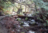
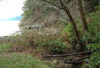
- Originates on the southwest side of Black Mountain. Flows down forested mountainside before appearing in the urban landscape near BC Ferries Horseshoe Bay ticket booth area. Proceeds under Marine Drive and through the Gleneagles Golf Course, followed by the forested Larson Bay Park. Discharges to the sea at Larson Bay over a cobble beach.
Watershed Use
- Residential: small urban influence
- Park: Larson Bay Park
- Recreational: Gleneagles RecCentre, Gleneagles Golf Course, Baden-Powell Trail
- School: Gleneagles Elementary School
- Fish: coho, chum at mouth, trout throughout
- Wetlands at junction of creek and Baden-Powell Trail
- Water licence held by the District of West Vancouver to use 36 acre foot per anum for purpose of watering
Concerns
- Obstructions or barriers to fish migration at culverts under the Upper Levels Highway and through the golf course
- Water quality altered through proximity to urban golf course and Upper Levels highway and ferry ticket waiting area
- Possible future development in upper watershed and associated problems, including an increase in imperviousness, the loss of wetlands and tributaries, construction of storm drain network resulting in altered water quality and quantity, encroachment into riparian zones, tributary channelization or loss, bank alteration and increased erosion into the creek
Watershed Projects
- Unfed coho fry release, since 2000
- Chum fry release from Nelson Creek Hatchery, since 2000
Prepared by Elizabeth Hardy, March 2003