Total Drainage Area = Unknown
Length = Unknown
Elevation Range: 0 - 40.00m
Characteristics
This watershed is bounded by Murray St and Knowle St to the North, St. Johns St and CPR Right of Way to the south, Ioco Rd. to the east and Lot A, Plan 16018 to the west.
Source believed to be either in the Chines hillside in Coquitlam or near Mundy Lake. With flow directly through an area of residential development
An estuarine wetland, in Shoreline Park forms the mouth of this creek.
Watershed Use
Ownership: IPSCO, CP Rail, Greystone, City of Port Moody
Landuse: Commercial, Industrial, Parks and Recreation, Residential, CP Right of Way.
Fish: Chum and Coho Salmon; Coastal Cutthroat Trout; Sculpins
Vegetation: Sitka spruce – Salmonberry; Black cottonwood - Willow
Concerns
Water quality is a concern, as is riparian losses, encroachment, unauthorized stream bed and bank alterations, access conflicts and stormwater impacts.
Six culverts carry stormwater into the brook from adjacent developed lands.
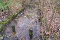
A 121 m of culvert passing under the railroad tracks through the works yard acts as an impassable barrier to salmonids.
The culvert below St. Johns is also impassable to salmonids.
The majority of this watershed has been developed, although there are large greenspaces (park areas) within the developed area.
Watershed Projects
Stocking of chum from Mossom Creek and Noons Creek hatcheries.
Suterbrook Project: development project to see Shoreline Park’s adjacent green spaces turned into medium density residential area. A 21 m buffer strip retained along Suterbrook.