Characteristics
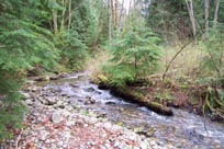
- Forested riparian ecosystem with a tidal flat at the outlet to Burrard Inlet.
- Source is near Eagle Mountain. Flow is southwest towards Burrard Inlet.
- Chum salmon are considered to use only the lower portions of Mossom Creek, but Coho have been reported above East Road in Anmore.
- Above East Road this creek is crossed by 2 BC Hydro transmission line right of ways. Both are 100 m wide with associated gravel access roads
History
- This watershed has been logged extensively. In the late 1800s and in the early 1970s.
- Approximately 12%of the watershed (above East Road) was logged during 1995-1996
- Mossom Creek has been used as a water source for many homes in the Anmore area, which continues to this day for several homeowners in the area.
Watershed Use
- Ownership: City of Port Moody, Government of Canada, Imperial Oil Company, Various private owners.
- Landuse: Industrial, Residential, Parks and Recreation, Agriculture, Forestry, CP Right of Way.
- Fish: Coho, Chum, Chinook and Pink Salmon; Coastal Cutthroat Trout; Three-spine Stickleback.
- Vegetation: Western Hemlock – Flat moss; Douglas fir/Western hemlock – Salal; Douglas fir – Swordfern; Western redcedar – Swordfern; Western redcedar – Salmonberry
Concerns
- Logging and associated access road construction have modified the hydrology of the watershed. There is evidence of heavy runoff flowing down access roads, and into storm drain system (top of Wyndham Crescent, Anmore.)
- Urbanization has affected the watershed through the addition of proportion of impervious areas
- Ditching in the Anmore area and storm sewers in Port Moody, act to divert surface drainage away from the Mossom Creek watershed.
- Critical fish habitat within the first 1 km of the stream from Burrard Inlet.
- Industrial activities in Burrard Inlet have previously polluted the marine environment receiving water from Mossom Creek.
- Since the 1990’s a series of large housing developments on the steep slopes above East Road in Anmore has affected the water quality and flow regime of Mossom Creek.
Key Interest Groups/Government Bodies
- Municipal Gov’t: City of Port Moody
- Regional Gov’t: GVRD, Vancouver Port Authority
- Provincial Gov’t: Ministry of Environment
- Federal Gov’t: Department of Fisheries and Oceans
- Local NGO’s: Mossom Creek Hatchery
Watershed Projects
- Burrard Inlet Marine Enhancement Society (BIMES) and Centennial High School operate a fish hatchery 1.2 km upstream from Burrard Inlet, since 1976. Both chum and coho salmon are reared and released.
Available Sources of Information
City of Port Moody
Port Moody Public Library
Port Moody Ecological Society Library
References
Baire, J. 1996. Mossom Creek Stream Survey, Port Moody B.C.. Prepared for BCIT Fish Wildlife and Recreation Program.
Dunster & Associates Environmental Consultants Ltd., and AXYS Environmental Consulting Ltd. 1999. Port Moody Environmentally Sensitive Areas Management Strategy. Phase 1: An Inventory of Natural Areas. Prepared for the City of Port Moody.
Fish Wizard. 2001. Mossom Creek Stream Report. Online: http://
Fraser River Action Plan. 1999. Lower Fraser Valley Streams (Vol.1): Strategic Review. Queens Printer. ISBN 0-662-26167-4
Poirier, B. 1999. Mossom Creek: Biophysical Inventory and Wetland Assessment. Prepared for Burrard Inlet Marine Enhancement Society.
Precision Identification Biological Consultants. 1997. Lower Fraser Valley Stream Review (Vol. 3): Wild, Threatened, Endangered and Lost Streams of the Lower Fraser Valley. Prepared for Fraser River Action Plan. Queens Printer. ISBN 0-662-26029-5