Wilkes Creek Watershed
Summary
Characteristics
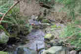
- Wilkes Creek originates near the City of Port Moody / Village of Anmore boundary and flows south-southwest, flowing under David Avenue, Heritage Mountain Boulevard, Parkside Drive, Ioco Road and Alderside Road before reaching Burrard Inlet.
- The watershed is bordered to the west by the Hett Creek watershed, to the east by the Turner Creek watershed, to the north by the Village of Anmore, and to the south by Burrard Inlet. The northeast corner of the watershed falls within the Village of Anmore boundaries.
- In 1996 11.3% of the watershed was developed and impervious to water and 80% of the riparian forest was intact, with a GVS&DD watershed health rating of 'good'.
- The upper section of Wilkes Creek is low gradient and runs through poorly defined channels which flood during rainfall events, allowing for groundwater storage. The lower section has a steeper gradient characterized by stable streambeds with boulder and cobble substrate.
Watershed Use
- Fish: the lowest 10 meters of Wilkes Creek (from culvert to mouth) is seasonally inhabited by juvenile salmonids. A systematic survey in December of 2001 found no resident salmonids, but sculpin likely inhabit this stream.
- Wildlife: various species including black bear, coyote, mule deer, and cougar. Several bird species utilise this area, including great blue herons.
- Vegetation: Western hemlock, Western red cedar, and Douglas fir dominate the stand composition.
- Parks: Bert Flinn Park, Foxwood Park, Wilkes Creek Ravine, the North Shore Escarpment and Old Orchard Park.
- Schools: the upper headwaters area has been set aside by the City of Port Moody "future community park and secondary school". Site clearing began in 2002.
- Residential: predominantly single-family residential houses with some condominiums.
- Other: CP Rail has a right-of-way through this watershed.
Concerns
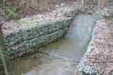
- Wilkes Creek is currently uninhabited by salmonids, with the exception of occasional strays at the stream mouth, due to severe channel alteration which includes numerous culverts impassable to fish. The most significant fish barrier is an approximately 100m long culvert from Ioco Road to the stream mouth.
- School and residential development may affect water quality: impervious (i.e. developed) area is predicted to increase from 11.3% in 1996 to 41.9% in 2036, with a resulting drop in watershed health from 'good' to 'fair'.
- Several provincially listed plant communities and at least one listed bird species inhabit this watershed.
- Marine sediment at creek mouth severely contaminatied by prior industrial activities.
Watershed Projects
- Ongoing water quality and fecal coliform monitoring by Port Moody Ecological Society.