Turners Creek Watershed
Summary
Characteristics
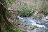
- Turners Creek originates as two branches, Turners Creek East and Turners Creek West, on the south side of Eagle Mountain. These two streams flow south-southwest, passing under David Avenue and joining to form Turners Creek approximately 100 meters upstream of Heritage Mountain Boulevard. Turners Creek continues south-southwest, passing under Ioco Road, San Remo Drive, and the CP Rail right of way before reaching Burrard Inlet.
- The watershed is bordered to the east by the Hutchinson Creek and Noons Creek watersheds, to the west by the Wilkes Creek watershed, to the north by the Village of Anmore, and to the south by Burrard Inlet. A small portion of the watershed lies within Village of Anmore boundaries.
Watershed Use
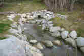
- Fish: coastal cutthroat and coho were present in this stream until the early 1970's when major stream alterations rendered the channel uninhabitable. The lowest 60 meters of Turners Creek, from stream mouth up to Shoreline Park bike path, was daylighted in 2002. One adult coho salmon was observed in December 2002 but there are no resident salmonids yet. Sculpin may inhabit this stream.
- Wildlife: various species inhabit this watershed.
- Vegetation: Western hemlock, Western red cedar, and Douglas fir dominate the stand composition.
- Parks: Turners Creek Ravine, Old Mill Park, and a portion of the North Shore Escarpment are all within this watershed.
- Schools: the upper headwaters area has been set aside by the City of Port Moody "future community park and secondary school". Site clearing began in 2002.
- Residential: predominantly single-family residential houses with some condominiums.
- Other: CP Rail and BC Hydro have right-of-ways through this watershed.
Concerns
- Turners Creek has numerous culverts which are impassable to fish, the most significant being an approximately 100m long culvert from Ioco Rd to below the Shoreline Park bike path
- Stormwater drainage, including the diversion of stormwater from Port Moody Neighbourhood 2 above Panorama Drive, will increas peak flows and may introduce water quality issues
- School and residential development may affect water quality: impervious (i.e. developed) area is predicted to increase from 21% in 1996 to 59% in 2036, which would degrade the watershed health rating from 'good' to 'poor'
- At least one provincially listed bird species and several provincially listed plant communities inhabit this watershed
- Marine sediments at the creek mouth have been severely contaminatied by prior industrial activities.
Watershed Projects
- Ongoing water quality and fecal coliform monitoring by Port Moody Ecological Society