Pigeon Creek Watershed
Profile
Characteristics
- Probably the most developed watershed in Port Moody
- Discharges into the Port Moody Arm of Burrard Inlet.
- Bordered to the south and west by the Slaughterhouse Creek watershed, to the east by the Suter Brook Creek watershed, and to the north by Burrard Inlet.
- Watershed catchment area has not been measured. Arial photos show approximately 90% of the watershed is developed and impervious to water.
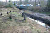
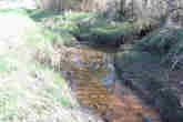
- Pigeon Creek originates in storm sewers draining the neigbourhood southeast of the intersection of St. Johns Street and Moray Street. Water passes through a culvert and daylights on the north side of St. Johns Street in front of the bingo parlor. Pigeon Creek then flows north for approximately 100 meters before entering another culvert on the south side of the CP Rail line. This culvert runs for approximately 500 meters below the CP Rail line and the IPSCO property, daylighting again just south of Murray Street. Pigeon Creek enters another culvert on the south side of Murray Street, emerging on the south side into Shoreline Park. Here it flows for approximately 50 meters to Pigeon Cove on the southeast corner of the Port Moody Mudflats.
History
- The Canadian Pacific (transcontinental) Railroad, which bisects this watershed, was completed in 1886. (City of Port Moody website).
- Industrial activities have polluted the marine environment of Port Moody Arm into which Pigeon Creek flows, leading Environment Canada to identify this area as an "environmental hotspot" in 1992 (Dunster and AXYS 1999). These pollutants include the metals cadmium, chromium, copper, lead, and zinc (originating from metal coating, plastic stabilizers, paint pigments, and, to a lesser extent, pesticides and sewage), as well as organic compounds like oil and grease hydrocarbons and polycylic aromatic hydrocarbons (originating from petroleum facilities). Polychlorinated biphenyls (PCBs, used to produce plastics, inks, paints and pesticides but banned since the mid-1970s) persist in low concentrations throughout Port Moody Arm. In 1987, all of these pollutants occured in the highest concentrations near the Ioco refinery, decreasing in concentration towards Indian Arm and the Port Moody tidal flats (Environment Canada 1989).
- IPSCO operated a pipe and steel plant in this watershed (between Murray Street and the CP Rail line) until 1980. The IPSCO site was recently used again (1999-2001) for the manufacture of concrete guidways for the Millenium Skytrain line. This site is currently slated for mixed-use development (City of Port Moody 1998), and sections of Pigeon Creek are to be daylighted (City of Port Moody Environmental Services personal communication).
- IPSCO was convicted under the Fisheries Act in 1998 for harming fish habitat (FOC 2001). The conviction was appealed and overturned.
Watershed Use
- Residential: predominantly single-family residential houses as well as a GVRD housing project. High density apartments are planned for the former IPSCO site.
- Industrial: several businesses operate along St. Johns Street.
- Parks and recreation: The mouth of Pigeon Creek flows through Shoreline Park.
- CP Rail has a right-of-way that runs east-west through the watershed.
- Fish: Chum (Onchorhynchus keta) anadramous Cutthroat Trout (Onchorhynchus clarki clarki), three-spined sticklebacks (Gasterosteus aculeatus) and prickly sculpin (Cottus asper) are resident in Pigeon Creek (FRAP 1999). Coho (Onchorhynchus kisutch) often stray in from neighboring Suter Brook Creek and Noons Creek (PMES observation).
- Wildlife: the highly developed state of this watershed means that coyotes and raccoons are the only prominent terrestrial animals inhabiting the area.
- Birds: a diverse bird assemblage inhabits Shoreline Park near the mouth of Pigeon Creek, including several species of woodpeckers, raptors, shorebirds and waterfowl. Blue heron and green-backed heron also inhabit this area. Historically, 131 bird species are known to inhabit the Port Moody area (Burke Mountain Naturalists 1994).
- Vegetation: Shoreline Park around Pigeon Cove is dominated by western hemlock (Tsuga heterophylla), western red cedar (Thuja plicata) and deer fern (Blechnum spicant). The northeast section of the watershed covers a section of a grove of black cottonwood (Populus balsamifera) and willow (Salix spp.) (Dunster and AXYS 1999).
Concerns
- Culverting: the majority of this stream runs underground. The Fraser River Action Plan (1999) recommends that culverted sections of the stream should be daylighted. Daylighting is planned for sections of Pigeon Creek on the IPSCO property.
- Stormwater: stormwater constitutes the majority of instream flows, resulting in an erratic flow regime and water quality issues. Port Moody Ecological Society has reported extremely high readings for conductivity and dissolved solids in Pigeon Creek. High counts of fecal coliform have also been recorded, possibly due to the periodic presence of squatters here and in the neighbouring Suter Brook watershed (PMES personal communication).
- Plant communities of concern: the black cottonwood / willow community is regionally / provincially blue-listed (of special concern).
Key Interest Groups
- Municipal Government: City of Port Moody
- Regional: GVRD, GVS&DD
- Provincial Government: Ministry of Transportation and Highways; Ministry of Environment, Lands and Parks; Burrard Inlet Environmental Action Program
- Federal Government: Fisheries and Oceans Canada, Environment Canada, Transport Canada
- Local NGO's: Port Moody Ecological Society
- BC Rail
- Various private landowners and occupants
Watershed Projects
- Ongoing water quality and fecal coliform monitoring by Port Moody Ecological Society.
- Future daylighting of Pigeon Creek on former IPSCO property by Polygon Homes Ltd.
Bibliography and Available Sources of Information