Characteristics
- Trillium Creek is a tributary of McCartney Creek
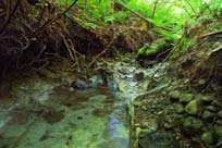
- The headwaters of Trillium appear to be culverted so that the first visible sign of the creek is as it flows out of a culvert under the path between Medwyn and Dunrobin. Trillium flows south between Emerson Court and Medwin Place and Walpole Crescent through a relatively natural forested area. South of Emerson Place, Trillium enters a deep forested ravine and flows southeast to join McCartney
- The Trillium Creek Watershed is bordered by the Blueridge Creek Watershed to the west and the McCartney Creek Watershed to the east
- The Trillium Creek Watershed is about 13% impervious surface (GVRD, 1999)
- Peak flow estimated at 0.18 km 2 estimated at .35 m3/sec
History
- Before mid-1800’s -North Vancouver District was inhabited by Coast Salish peoples.
- 1860’s - The first significant non-native settlement began
- 1870-1926 – Old growth forest logged
- Early 1900’s – Accidental introduction of white pine blister rust (Cronartium ribicola) results in the loss of most of the Western white pine on the North Shore
- 1925 - Completion of 2nd Narrows Bridge
- Late 1940’s – Balsam woody aphid (Chermes piceae) introduced which impacts Amabilis firs
Watershed Use
- Fish: Cutthroat
- Strong fish population observed during preliminary assessment in spring 2001 (NSSK, 2001)
- 2 cutthroat trapped below Dunrobin Cr. and 6 trapped below Emerson Way in the 1993 Fish Trapping Survey (District of North Vancouver, 1993)
- Wildlife: besides providing habitat for various species of reptiles, amphibians, birds and mammals, the riparian corridor serves as a travel corridor. Likely species include: shrews, moles, weasels, bobcat, lynx, deer, fox, raccoon, otter, hares, coyote and bear, but no wildlife studies have been conducted.
- Vegetation: Coastal Western Hemlock, dry subzone. Remaining native trees in watershed include western hemlock, douglas-fir, western red cedar, big leaf maple, and red alder up to about 120 years old.
- Parks: McCartney Creek Park, Trillium Park
- Residential: the area surrounding Trillium Creek is primarily residential
- Schools: Seymour Heights Elementary, Blueridge Elementary
Concerns
- 5 storm drains flow into Trillium
- Trillium is culverted in its upper reaches and possibly in its headwaters
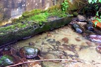
- High level of suspended sediments noted in the water during preliminary watershed assessment in spring, 2001 (NSSK, 2001)
Key Interest Groups/Government Bodies
- Municipal Gov’t: District of North Vancouver (DNV); District Parks Department
- Regional: GVRD (regional parks, sewers and air quality); GVWD
- Provincial Gov’t: Ministry of Transportation and Highways; Ministry of Environment, Lands and Parks
- Federal Gov’t: Department of Fisheries and Oceans; Environment Canada; Transport Canada
- Local NGO’s: North Shore Streamkeepers; North Shore Fish and Game Club; Pacific Streamkeepers Federation; ? Community Association
- School District 44
Watershed Projects and Good News
- Most of Trillium Creek has good to excellent riparian cover
Recommendations and Suggested Actions
- Development of lots adjacent to creek courses and ravines should be carefully controlled. No vegetation should be removed on creek or ravine slopes. No waste or development fills should be placed over creek or ravine slopes or within 25 ft. of the crest of such slopes. No storm run-off through culverts or channels should be discharged above or on creek or ravine slopes. Any system discharging ground and surface water to creeks should be constructed in such a way that they do not increase the rate of erosion. Any increase in average or peak creek flows will increase the present rate of bed degradation. Clearing and building should not be carried out such that debris from development sites may be transported to the creek channels. Installation of culverts in the creeks should be done in such a way that present erosional paths of the creeks are not altered (Tera Planning Ltd., 1991)
- Development should not occur on the steep portions of the creek and vegetation should be retained. A setback of a minimum of 10 m. from the top of bank should be maintained to avoid impacts on the creek system. Seepage areas adjacent to McCartney and Trillium should be maintained and incorporated into a greenbelt area. A vegetation and conservation management strategy should be integrated into the design of the residential neighbourhood. Residential design should minimize the direct runoff of storm water into the storm sewer (deflection of runoff from impermeable and less permeable surfaces should be through retention structures to dampen peak flows and improve water quality (Tera Planning Ltd., 1991)
- Implementation of a conservation plan along creek corridors should be considered (Tera Planning Ltd., 1991)
Available Sources of Information
BC Ministry of Environment, Lands and Parks. TRIM/UTM Maps.
Bouton, Cherry. (2000). North Shore History. www.cherrybouton.com/nshistory.html
Canada: Department of the Environment. (August 1971). "The Burrard Inlet-Howe Sound Area: Preliminary Prescription of Existing Environmental Conditions. Draft Report."
Department of Fisheries and Oceans. (1989). Stream Summary Catalogue.
District of North Vancouver Fish Trapping Summary. (1993). Unpubl.
District of North Vancouver. (2001). GIS Database. North Vancouver: District of North Vancouver.
District of North Vancouver. Seymour Official Community Plan.
District of North Vancouver. Storm Drain Maps.
Don Vaughan & Associates. (19??). "Development Limitations and Implications for the Seymour Heights Site.
Golder Associates - Consulting Geotechnical Engineers. (1979). "Report to Corporation of the District of North Vancouver: Re: Design Techniques for Proposed Residential Housing East of Seymour River."
GVRD. (August 1999). Assessment of Current and Future GVS&DD Area Watershed and Catchment Conditions. Prepared for: Liquid Waste Management Plan. Stormwater Management Technical Advisory Task Group.
Kahrer, Gabrielle. (1989). From Speculative to Spectacular: The Seymour River Valley 1870’s to 1980’s: A History of Resource Use. (GVRD Parks Department).
Norecol Environmental Consultants Ltd. (1991). Memorandum Re: Fish Collection for Proposed Burke Mountain Resort Development and Northlands Golf Course Development. Vancouver BC.
North Shore Streamkeepers. (Spring 2001). Preliminary Watershed Assessments of 12 North Shore Creeks. Unpubl.
Tera Environmental Consultants Ltd. (October 1989). Biophysical Inventory and Sensitivity Analysis for the Seymour-Lynn Inter-river lands. Prepared for the District of North Vancouver.
Tera Planning Ltd. (July 1991). "Environmental Assessment of the McCartney Woods Neighbourhood, North Vancouver." Prepared for the District of North Vancouver Planning Department.
Water Licenses: http://www.elp.gov.bc.ca:8000/pls/wtrwhse/water_licences.input