Characteristics
- Thames Creek is the main tributary of Hastings Creek which is one of the most important small fish-bearing streams in North Vancouver (Renshaw). Thames headwaters north of the urban development of Lynn Valley and flows south through residential area in Lynn Valley until it joins Hastings Creek at Ross Road
- Lower reaches flow through a highly residential area
- Thames Creek is bordered by the Coleman Creek Watershed to the west and the Pierard Creek Watershed to the east
- 21% impervious surface in the Hastings Creek Watershed (GVRD, 1999)
- 54% of the Hastings Creek Watershed had forest cover (GVRD, 1999)
- Thames' water flow is estimated at a high of 76 cubic feet/second in January to a low of 6 cubic feet/second in August
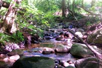
- Thames Creek Reach 1 has the following characteristics which make it excellent juvenile rearing habitat (Methven, 1987):
- A low velocity of .08 m/sec
- an equal pool-riffle ratio, each comprising 44% of the total area
- a variety of substrate types consisting of 10.8% fines, 21.7% small gravel. 26.7% large gravel, 23.7% cobble, 12.1% small boulders and 5% bedrock
- a variety of cover including undercut banks comprising 9% of the total area, overstream vegetation comprising 10.4% of total and stable debris
History
- Hastings Creek and its numerous tributaries made up the prime spawning area for most of the Lynn’s migratory runs of cutthroat, steelhead, coho and chinook. This watershed contained excellent spawning and rearing habitat for salmon and trout, and had strong coho runs.
- 1860’s - The first significant non-native settlement began as the Douglas-fir and Western white pine were cut for spars or sailing ship masts and exported to Britain for Royal Navy ships. Lynn Valley became known as spar forest as it provided spars 70 feet long and 13 feet in diameter
- 1875 – Logging for red cedar bolts became the main activity
- 1899 - First home in Lynn Valley built by J.M. Fromme in a clearing from the logging (Eikos Design Group, 1978) (Draycott, W. M., 1919)
- Early 1900’s – Accidental introduction of white pine blister rust (Cronartium ribicola) results in the loss of most of the Western white pine on the North Shore
- 1903 – Lynn Valley Lumber Co’s Upper Mill opens. Located west of Thames Creek at the east end of Mill Street. Managed by Julius M. Fromme (Stewart 1975)
- 1907 – Upper Mill closes
- Thames Flood Events: 1909, 1914, 1919, 1933, 1949, 1955, 1958, 1961 (three), 1968 (Resource Analysis Branch, MOE, 1977)
- Late 1940’s – Balsam woody aphid (Chermes piceae) introduced which impacts Amabilis firs
- Late 1950’s – wave of residential housing in Lynn Valley. 2nd Narrows opened in 1958
- 1962 - 7-foot high wall built below Arbourlynn culvert to control flooding stops fish passage (Stewart, 1975)
- Early 1960's - Salmon unable to reach spawning grounds in Kilmer, Thames, Hoskins, Pierard after a culvert is installed at Hoskins Road (Eikos Design Group, 1978)
- 1960-70’s - Westlynn area at mouth of Hastings developed as residential area
Watershed Use
- Fish: Cutthroat Trout
- Fry observed north of Dovercourt Road during Preliminary Watershed Assessment in May 2001 (NSSK, 2001)
- 8 cutthroat trapped below Dempsey Road and 1 below McNair Road in the 1993 Fish Trapping Survey (District of North Vancouver, 1993)
- Survey shows large population of coho salmon, cutthroat trout and steelhead in Reach 1 (from Hastings Creek to Lynn Valley Road) of Thames Creek (Methven, 1987)
- Wildlife: Various species including raccoons, mink, river otters, black bears, Belted Kingfishers, Dippers, Great Blue Herons, Common Mergansers, Harlequin Ducks, and Swallows (Tera Environmental Consultants Ltd.)
- Vegetation: Coastal Western Hemlock, dry subzone. Remaining native trees in watershed include western hemlock, douglas-fir, western red cedar, big leaf maple, and red alder up to about 120 years old
- Residential: The area surrounding Thames is highly residential with mostly single family dwellings
- Parks: Upper reach parallels Baden-Powell Trail
Concerns
- Stream classified as endangered due to impacts (FRAP)
- Significant loss of riparian vegetation along more than 50% of the fish frequented length of the stream due to development and removal by landowners (FRAP)
- Urbanization in the watershed has significantly affected the stream basin (FRAP); 17 storm drains flow into Thames
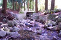
- Channelization and/or armourization (riprapping) of over 50% of the fish frequented length of the stream (FRAP)
- Bank and slope stability leading to erosion and flooding. Progressive sedimentation and plugging of trash racks at culvert inlets under flood flow conditions in tributary channels in upper reaches (Kerr Wood Leidal Associates, 1982)
- Road construction in the 1950’s created impassable culverts, severely reducing the coho runs
- Houses are located within creek floodplain
- Status: Endangered - due to riparian removal, urbanization, culverting and degraded water quality
- 21% impervious area in watershed (GVRD, 1999)
- There is a high incidence of alien plant species in this watershed
- A local resident indicated that frogs and crayfish used to be present in the Creek, but are no longer there
- Children catch and kill the fry
- Neighbours have been removing large organic debris from the creek
Key Interest Groups/Government Bodies
- Municipal Gov’t: District of North Vancouver (DNV); District Parks Department; Lynn Canyon Ecology Centre
- Regional Gov’t: GVRD (regional parks, sewers and air quality); GVWD
- Provincial Gov’t: Ministry of Transportation and Highways; Ministry of Environment, Lands and Parks
- Federal Gov’t: Department of Fisheries and Oceans; Environment Canada; Transport Canada
- Local NGO’s: North Shore Streamkeepers; North Shore Fish and Game Club; Pacific Streamkeepers Federation; Lynn Valley Community Association
- BC Hydro
- School District 44
- North (Shore/Vancouver) Historical Society
Recommendations and Suggested Actions
- Preservation of greenbelts adjacent to watercourses is recommended for prevention of flooding problems and preservation of community values (Resource Analysis Branch, MOE, 1977)
- The success of enhancement programs require maintenance of water quality, provision for adequate minimum summer flow levels, and maintenance of essential stream characteristics including pool and riffle development, gravelly bouldery stream beds, and minor lateral erosion. The effect on these factors of additional development in the upper Hastings basin must be carefully evaluated (Eikos Design Group, 1978)
- Thames Creek is culverted at Burrill Road beneath a walking trail. This section could be daylighted in favour of a footbridge which would eliminate the barrier this culvert presents to upstream fish passage (NSSK, 2001)
Bibliography and Available Sources of Information
BC Ministry of Environment, Lands and Parks. TRIM/UTM Maps.
Bouton, Cherry. (2000). North Shore History. www.cherrybouton.com/nshistory.html
Canada: Department of the Environment. (August 1971). "The Burrard Inlet-Howe Sound Area: Preliminary Prescription of Existing Environmental Conditions. Draft Report."
Clark, B. (1985). Hastings Creek Habitat Evaluation. MoE: Fish and Wildlife Branch. Surrey, B.C.
De Leeum, A.D. and K.M. Stuart. (1981). Resource Atlas for Lower Mainland Sea-run Cutthroat Study. MOE: Fish and Wildlife Branch. Surrey, BC.District of North Vancouver Fish Trapping Summary. (1993). Unpubl.
Department of Fisheries and Oceans. (1989). Stream Summary Catalogue.
District of North Vancouver. GIS Database.
District of North Vancouver. Lynn Valley Official Community Plan.
District of North Vancouver. Storm Drain Maps. Map Pages: I-14, J-14, J-13, J-12, J-11, J-10.
District of North Vancouver. (1974). "Summer Project: A Study of Fish Habitats". North Vancouver: District of North Vancouver.
District of North Vancouver Website. (2001). Hastings Creek Salmon Restoration Update. www.district.north-van.bc.ca/admin2/depart/enviro/hastings%5Fcreek %5Fupdate.html or search for Hastings Creek on the NV District site.
Draycot, Walter. (1912). "Lynn Valley: From the Wilds of Nature to Civilization". North Vancouver.
Draycot, Walter. (February 2000). Early Days in Lynn Valley. North Vancouver, BC: Contact Printing and Mailing Ltd.
Eikos Design Group. (1978). "Lynn Valley Environmental Analysis: A Technical Overview Report."
Gabby. "Logging History of the North Shore". (1994). North Vancouver: Lynn Canyon Ecology Centre Library.
GVRD. (August 1999). Assessment of Current and Future GVS&DD Area Watershed and Catchment Conditions. Prepared for: Liquid Waste Management Plan. Stormwater Management Technical Advisory Task Group.
North Shore Streamkeepers. (Spring 2001). Preliminary Watershed Assessments of 12 North Shore Creeks. Unpubl.
The Lynn-Seymour Rivers and the Hastings Stream: Geologic History of Their Origin.
Maynard, Denny. (1977). Guidebook for Geologic Field Trips in the Lynn Canyon-Seymour Area of North Vancouver. Dept. of Geologic Science, UBC.
Methven, Sharon. (1987). "Bio-Physical Survey of Lower Lynn Creek and Tributaries". North Vancouver: Lynnmour Community School Association.
Nix, P.G. and C.H. Merry. E.V.S. Consultants. (August 1989). "Fecal Bacterial Levels in Major Streams Within the District of North Vancouver. Prepared for Director of Engineering Services, District of North Vancouver.
GVRD. (August 1999). Assessment of Current and Future GVS&DD Area Watershed and Catchment Conditions. Prepared for: Liquid Waste Management Plan. Stormwater Management Technical Advisory Task Group.
Kahrer, Gabrielle. (1989). From Speculative to Spectacular: The Seymour River Valley 1870’s to 1980’s: A History of Resource Use. (GVRD Parks Department).
Norecol Environmental Consultants Ltd. (1991). Memorandum Re: Fish Collection for Proposed Burke Mountain Resort Development and Northlands Golf Course Development. Vancouver BC.
North Shore Streamkeepers. (Spring 2001). Preliminary Watershed Assessments of 12 North Shore Creeks. Unpubl.
Precision Identification Biological Consultants. (1997). Prepared for Fraser River Action Plan, Fisheries and Oceans Branch. Wild, Threatened, Endangered and Lost Streams of the Lower Fraser Valley: Summary Report. Lower Fraser Valley Stream Review, Vol. 1 & 3.
Renshaw, Timothy. December 12, 1990. "North Shore fish battle to survive in a polluted urban environment". in the North Shore News. (North Shore Archives).
Resource Analysis Branch, Ministry of the Environment. (1977). "Resource Analysis For Urban Suitability: Vancouver's Northshore Area."
Stevens, Victoria and A. Eriksson. "Current Trends Along the Lower Fraser River". Government of Canada. Vancouver, 1997.
Steward, Barry. "Lynn Valley’s Creeks and Fish Habitats". (1975). North Vancouver: Lynn Canyon Ecology Centre. (North Shore Archives).
Tera Environmental Consultants Ltd. Seymour-Lynn Vegetation and Wildlife Species List.
Water Licenses: http://www.elp.gov.bc.ca:8000/pls/wtrwhse/water_licences.input