Characteristics
- Taylor Creek is fed by ground and surface water originating on the slopes of Mt. Seymour (Golder Associates, 1979). Taylor flows south down the mountain and is crossed by Anne MacDonald Way. Further south, Taylor flows between Parkgate Avenue and Mount Seymour Road and then between Bowron Court and Roche Point Drive on the south side of Mount Seymour Parkway. Taylor is crossed by Garibaldi Drive and then flows southwest through the Burrard Band Reserve, under Dollarton Highway and into Burrard Inlet.
- Swampy conditions appear to be related to the decreased gradient at the base of Mt. Seymour, high levels of ground water flow, a permeable soil of sand and silt, and less permable soils underlying the sand and silt (Golder Associates, 1979)
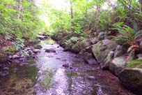
- Area comprised of various surface features including high bedrock outcroppings, well drained forested areas and low, swampy, thickly vegetated areas (Golder Associates, 1979)
- Bedrock underlying area consists of strong igneous rocks classed as diorite and granodiorite (Environment Research Consultants, 1975)
- Creekbed material characterized by sand, gravel and boulders up to 1 foot. The deposits are generally less than 1 foot thick (Environment Research Consultants, 1975)
- Soils in area are predominately podzolic-forested soils that tend to be highly leached, relatively acid and very productive for the natural forest (Environment Research Consultants, 1975)
- Humus tends to be 3-4 inches thick, although along creek beds it reaches a thickness of up to 2 feet (Environment Research Consultants, 1975)
- There are isolated areas of poor drainage at the top end of the Creek (Environment Research Consultants, 1975)
History
- Taylor Creek valley appears to have been created before or during glacial time (Environment Research Consultants, 1975).
- Before mid-1800s -North Vancouver District was inhabited by Coast Salish peoples.
- 1900 - Area selectively logged for Douglas-fir and western red cedar. Subsequently burned about 1905 (Environment Research Consultants, 1975)
- Early 1900’s – Accidental introduction of white pine blister rust (Cronartium ribicola results in loss of most of the Western white pine on the North Shore
- 1925 - Completion of 2nd Narrows Bridge
- Late 1940’s – Balsam woody aphid (Chermes piceae) introduced and impacts Amabilis firs
- 1955 - Flood washes out Indian River Drive and isolates a number of homes
- 1968 - washouts on Dollarton Hwy. (Resource Analysis Branch, MOE, 1977)
Watershed Use
- Fish: cutthroat
- 6 cutthroat trapped above Parkgate Ave. in 1993 Fish Trapping Survey (District of North Vancouver, 1993)
- Strong cutthroat populations noted above and below Mount Seymour Parkway (NSSK, 2001)
- Wildlife: estimated that at least 83 bird species and 15 mammal species occur in the area as residents or visitors (Environment Research Consultants, 1975). Species include red-tailed hawk, American kestrel, northern flicker, pileated woodpecker, downy woodpecker, Stellar's jay, common raven, northwestern crow, black-capped chickadee, chestnut-backed chickadee, common bushtit, red-breasted nuthatch, brown creeper, winter wren, American robin, golden-crowned kinglet, ruby-crowned kinglet, pine siskin, rufous-sided towhee, dark-eyed junco, song sparrow, sharp-shinned hawk, common nighthawk, cedar waxwing, black-tailed deer, black bear, deermouse, dusky shrew, raccoon, and Douglas squirrel
- Vegetation: - Coastal Western Hemlock, dry subzone. Secondary forest with various community types with tree species of 65-120 years in the main story. Remaining native trees in watershed include western hemlock, douglas-fir, western red cedar, big leaf maple, and red alder up to about 120 years old
- Parks: Mount Seymour Provincial Park, Garibaldi Park, trails, dog-walking, mountain biking
- Residential: single and multi-family housing between Garibaldi Park and Parkgate Shopping Mall
- Reserve: Burrard Inlet First Nations Reserve
- Commercial: Parkgate Shopping Mall, and Northlands, Seymour, and Takaya Golf Courses
- District of North Vancouver: Parkgate Library, Parkgate Community Centre and Skateboard Park
Concerns
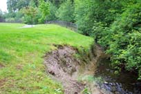
- There has been substantial impact to Taylor Creek and its riparian zone in the short time since the Parkgate Community Centre and Skateboard Park were built. The riparian corridor has been degraded through extensive foot and bike traffic. Informal bike trails go through the creek (particularly at the end of Banff Road). Trails are too close to the creek and are causing erosion (NSSK, 2001)
- The construction of Anne MacDonald Way has negatively impacted Taylor Creek
- Clearing for development would remove much of the forest and cover and their capacity or interception and subsequent evaporation of a proportion of the rainfall and flood flows in the watercourses would be increased sustantially. This could be minimized by preserving the environment in its natural condition over as large an area as possible. Stream banks and the areas in their immediate vicinity should be left undisturbed to minimize local runoff and reduce erosion (Environment Research Consultants, 1975)
- 9 storm drains flow into Taylor Creek
- Water quality in the natural watercourses is likely to deteriorate as a result of development of the area. Contributary factors are the more rapid conveyance of storm water and its load to creeks and the introduction of pollutants from human activities such as oil, pesticides and fertilizers (Environment Research Consultants, 1975)
- Taylor Creek is surrounded by 3 golf courses.
- In Garibaldi Park, the riparian zone has been removed right to the creekbank and replaced with grass
- Homeowner(s) on Ruckle Road are dumping yard clippings in the wooded areas of Garibaldi Park
- A water main is in the creekbed north of Anne MacDonald Way
Key Interest Groups/Government Bodies
- Municipal Gov’t: District of North Vancouver (DNV); District Parks Department
- Regional Gov’t: GVRD (regional parks, sewers and air quality); GVWD
- Provincial Gov’t: BC Parks (Mount Seymour Provincial Park); Ministry of Transportation and Highways; Ministry of Environment, Lands and Parks
- Federal Gov’t: Department of Fisheries and Oceans; Environment Canada; Transport Canada
- Tseil Watuth - Burrard Band
- Local NGO’s: North Shore Streamkeepers; Pacific Streamkeepers Federation; Local Community Association
- Northlands, Seymour, and Takaya Golf Courses
- Parkgate Shopping Mall
- BC Hydro
- School District 44
- North Shore Historical Society
Watershed Projects and Good News
- 1993 - Stream improvement beside Hamber Place
- Stream improvement below Mount Seymour Parkway
- In spite of the impacts to the creek, Taylor is still home to a strong population of cutthroat
Recommendations and Suggested Actions
- Taylor Creek is surrounded by 3 golf courses. Proper management plans including water quality plans are needed to ensure that the creek is protected
- The riparian zone should be restored in Garibaldi Park
- A District ‘no dumping’ sign should be put in at the end of Ruckle Road to ensure homeowners are aware of the bylaw and fine against dumping yard clippings (NSSK, 2001)
- There have been a number of negative impacts to Taylor Creek in recent years. Subsequent development should carefully consider the impact to the creek before proceeding (NSSK, 2001)
- "Development of lots adjacent to creek courses and ravines should be carefully controlled. No vegetation should be removed on creek or ravine slopes. No waste or development fills should be placed over creek or ravine slopes or within 25 ft. of the crest of such slopes. No storm run-off through culverts or channels should be discharged above or on creek or ravine slopes. Any system discharging ground and surface water to creeks should be constructed in such a way that they do not increase the rate of erosion. Any increase in average or peak creek flows will increase the present rate of bed degradation. Clearing and building should not be carried out such that debris from development sites may be transported to the creek channels. Installation of culverts in the creeks should be done in such a way that present erosional paths of the creeks are not altered" (Environment Research Consultants, 1975).
- "Stream containing permanent or semi-permanent flows of water should remain undisturbed with a protective vegetation cover beyond the break in the slope of the area. The leave strip should be sufficiently wide to maintain the stability of the ravine shoulder from slumping and erosion and to retain the aesthetic values of these areas" (Environment Research Consultants, 1975)
- Taylor Creek "is a prime area for preservation because of a creek environment location which confers a distinct microclimate and soils regime resulting in a wide diversity of species, both in forest cover and in ground vegetation." (Environment Research Consultants, 1975).
- "A belt of forested land, 100-120 feet wide, should be left undisturbed along Mt. Seymour Road to reduce noise pollution affecting adjacent residential development" (Environment Research Consultants, 1975)
- "Properly designed foundation drainage systems are required due to the impermeability of the underlying basal till" (Environment Research Consultants, 1975)
- "Construction should not be carried out in the creek valley. Clearing of vegetation or removal of topsoil could result in flood conditions because of the inability of the underlying basil till to admit and retain surface water" (Environment Research Consultants, 1975)
- "Areas of bedrock outcrops are unfavorable for building sites as excavations for services such as sewer and water would have to be blasted" (Environment Research Consultants, 1975)
- "Any activity which would cause disruption of the natural groundwater flow would have to be carried out with care, as excess water could cause ponding of water and subsequent changes in vegetation and stream hydrology" (Environment Research Consultants, 1975)
Available Sources of Information
Map: TRIM/UTM - BC Ministry of Environment, Lands and Parks
Map: District of North Vancouver
Water Licenses: http://www.elp.gov.bc.ca:8000/pls/wtrwhse/water_licences.input
Bouton, Cherry. (2000). North Shore History. www.cherrybouton.com/nshistory.html
Canada: Department of the Environment. (August 1971). "The Burrard Inlet-Howe Sound Area: Preliminary Prescription of Existing Environmental Conditions. Draft Report."
Department of Fisheries and Oceans. (1989). Stream Summary Catalogue.
District of North Vancouver Fish Trapping Summary. (1993). Unpubl.
District of North Vancouver. (2001). GIS Database. North Vancouver: District of North Vancouver.
District of North Vancouver. Seymour Official Community Plan.
District of North Vancouver. Storm Drain Maps.
Environment Research Consultants. (1975). "Landscape Reconnaissance: Seymour Park West". for the Planning Department of the District of North Vancouver.
older Associates - Consulting Geotechnical Engineers. (1979). "Report to Corporation of the District of North Vancouver: Re: Design Techniques for Proposed Residential Housing East of Seymour River.
North Shore Streamkeepers. (Spring 2001). Preliminary Watershed Assessments of 12 North Shore Creeks. Unpubl.
R.A. Spence Engineering Inc. (August 1979). Geotechnical Considerations for Planning of Indian River, Winridge and Maplewood Community Areas.
Resource Analysis Branch, Ministry of the Environment. (1977). "Resource Analysis For Urban Suitability: Vancouver's Northshore Area."
Tera Consultants Limited. (June 1976). Landscape Reconnaissance of Blair Rifle Range Recon Areas 14A and 14B. Prepared for Central Mortgage and Housing and the District of North Vancouver.