Keith Creek Watershed
Summary
Characteristics
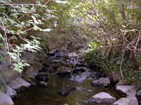
- Keith Creek originates north of Lynn Valley Road and flows southeast through the District and the City of North Vancouver. Keith joins Lynn Creek just north of Keith Road and west of Mountain Hwy
- bordered by the Wagg Creek Watershed (Mosquito Creek) to the west, the Lynn Creek Watershed to the east and the Hastings Creek Watershed to the north
Watershed Use
- Fish: Coho Cutthroat, Sculpin and Steelhead
- Wildlife: –various species
- Vegetation: - Coastal Western Hemlock, dry subzone.
- Parks: Loutet Park; Lynn Canyon Park; Keith Lynn Park; Bridgeman Park
- Schools: Keith-Lynn Elementary School; Boundary School; Sutherland High School
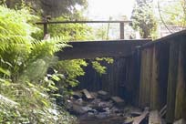
- Highway: Runs alongside and beneath the Trans-Canada Highway
- Residential: flows through residential areas in District and City of North Vancouver
- Commercial: Various businesses
Concerns
- Stream classified as endangered due to impacts (FRAP)
- Watershed Health defined as fair declining to poor due to present development and stormwater management practices (GVRD, 1999)
- 21% impervious area in watershed (GVRD, 1999)
- Water quality – Significant problems caused by urban development (FRAP)
- 24 storm drains flow into Keith
- Urbanization in the watershed has significantly affected the stream basin (FRAP)
- Bank and slope stability leading to erosion and flooding (Kerr, 1982).
Watershed Projects
- 1992 and 93 - Lynnmour School students released fry into Keith Creek
- Incubation box installed at the junction of Keith and Lynn Creeks
- Pool-riffle sequence enhanced between Keith Road & Upper Levels bridge