Hoskins Creek Watershed
Summary
Characteristics
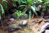
- Hoskins originates north of Lynn Valley Road and is culverted between Peters Road and Platt Crescent. Hoskins flows south through a residential neighbourhood until it joins Hastings Creek in Hastings Creek Park?
- Hoskins Creek is a tributary of Hastings Creek
- Hoskins Creek is located between the Lynn Creek Watershed to the east and the Pierard Creek Watershed to the west
- 21% impervious surfaces in the Hastings Creek Watershed (GVRD, 1999)
- 54% of the Hastings Creek Watershed had forest cover (GVRD, 1999)
Watershed Use
- Fish: Coho
- Wildlife: Various species
- Vegetation: Coastal Western Hemlock, dry subzone
- Parks: Pierard Park; Draycott Park; Hastings Creek Park
- Schools: Westover Elementary; Ross Road Elementary
- Residential: the area surrounding Hoskins Creek is primarily residential
Concerns
- 18 storm drains flow into Hoskins Creek
- High incidence of introduced plant species
- 21% impervious area in watershed (GVRD, 1999)
- The culverts at Ross Road are a barrier to fish migration (NSSK, 2001)
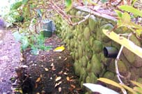
- Hoskins Creek is being used as a trash dump in Hastings Creek Park (below Haverhill Place) (NSSK, 2001)
- Loss of riparian zone north of Ross Road
Watershed Projects and Good News
- The lower reach of Hoskins Creek is protected in a park