Characteristics
- Gallant Creek is one of 2 fish-bearing creeks that flow into Deep Cove. Gallant originates on the east side of Mount Seymour. This beautiful creek is relatively untouched in its upper reaches except where it is intersected by Mount Seymour Road and 3 times by Indian River Drive. In its lower reaches, Gallant has been heavily impacted by urban development.
- A number of small tributaries flow into Gallant Creek
- Gallant Creek is bordered by the Panorama Creek Watershed to the north and Parkside and Taylor Creek Watersheds to the south
- Deep Cove receives annual precipitation of 80-90 inches at sea level, increasing by 12 inches for every 1000 ft. increase in altitude (Environmental Research Consultants, 1973)
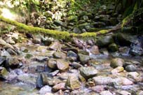
- Creekbed material is characterized by cobbles and boulders up to 2 meters in size. Silt, sand and gravel also occur.
- The creek valley appears to have been created before or during the glacial period as it is underlain by tills similar to those elsewhere in the area (Environment Research Consultants, 1973)
History
- 2000 years ago - People of the Tsleil'watuth Nation (Burrard Band) lived in the Indian Arm area
- Early 1900’s – Accidental introduction of white pine blister rust (Cronartium ribicola results in loss of most Western white pine on the North Shore
- 1918-1926 - Deep Cove Logging Co. began operations in 1918 in the present day Mount Seymour Provincial Park. The company was so successful that the timber limits were exhausted by 1926 and the company ceased operation.
In order to log, a portable sawmill and a planked roadway 8-10 feet wide were built
- 1908-1924 - Granite quarry operated at site of Seycove Marina
- 1907 - First residential cottages built along the waterfront at Deep Cove
- 1925 - Completion of 2nd Narrows Bridge increases residential development
- 1926 - Deep Cove Park dedicated
- Late 1940’s – Balsam woody aphid (Chermes piceae) is introduced and impacts Amabilis firs
- 1951 - Panorama Park established
Watershed Use
- Fish: Cutthroat
- 4 cutthroat found above Indian River Road and 3 below in Fish Trapping Survey (District of North Vancouver, 1993)
- Cutthroat observed above Indian River Drive (NSSK, 2001)
- Wildlife: besides providing habitat for various species, the riparian corridor serves as a travel corridor.
- Mink and river otter once used this area (Environmental Research Consultants, 1973). Current populations are unknown
- Vegetation: Coastal Western Hemlock Zone, dry subzone with transitions to the wet subzone at higher elevations. Over 200 plant species including trees, shrubs, and ground cover (Environment Research Consultants, 1973). Largely coniferous 2nd growth forests of Western hemlock, Douglas-fir, and western red cedar with patches of largely deciduous forest of alder, vine maple and big leaf maple. "Species rich groundcover communities border...streams" (Environment Research Consultants, 1974).
- Parks: Panorama Park, Deep Cove Park, Mount Seymour Provincial Park
- Trails: Old Buck Logging Trail, Baden-Powell Trail
- Residential: single and multi-family dwellings along lower reaches
- Commercial: Marina, art gallery, various businesses along Deep Cove Road
Concerns
- "The creek basin is fed by a system of open ditches and storm sewers. High fecal coliform levels (most notably dog faeces) are associated with storm water runoff from urban areas" (Dayton & Knight Ltd, 1989).
- 6 storm drains flow into Gallant Creek in its lower reaches
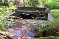
- Extensive culverting of Gallant in its lower reaches blocks fish passage. Gallant Creek is culverted from the northeast corner of the Seymour Art Gallery, under Panorama and Gallant Roads, to the intersection of Gallant Road and Deep Cove Road. Gallant daylights briefly above Gallant Road, but is cemented on the bottom and bank left. (NSSK, 2001).
- The lower reaches of Gallant have been heavily impacted by urbanization. Above Deep Cove Road, Gallant is armoured on both sides and bottom for 30 m and houses constrain the creek on both sides. One house is being constructed straddling the creek. Upstream of Badger Road, the creek is armoured bottom and sides for 100 m. (NSSK, 2001)
- Creeks in central Deep Cove have only 26% forest cover left in their riparian corridors. As well, there is 19% of the watershed in central Deep Cove are covered by impervious surfaces (GVRD, 1999)
- There appears to be a small water pump in the creek at Indian River Drive. Purpose unknown (NSSK, 2001)
Key Interest Groups/Government Bodies
- Municipal Gov’t: District of North Vancouver (DNV); District Parks Department
- Regional Gov’t: GVRD (regional parks, sewers and air quality); GVWD
- Provincial Gov’t: BC Parks; Ministry of Transportation and Highways; Ministry of Environment, Lands and Parks
- Federal Gov’t: Department of Fisheries and Oceans; Environment Canada; Transport Canada
- Local NGO’s: North Shore Streamkeepers; North Shore Fish and Game Club; Pacific Streamkeepers Federation; Local Community Association
- BC Hydro
- School District 44
- North (Shore/Vancouver) Historical Society
- Seymour Art Gallery
- Deep Cove Historical Society
Watershed Projects and Good News
- The upper reaches of the creek are very healthy. Creek is highly complex with a variety of habitat types and a good riparian zone
- The headwaters of Gallant Creek are protected in Mount Seymour Provincial Park
- Box culverts have been used on Indian River Drive. These culverts leave the substrate intact and allow for normal fish migration
- Other than some isolated growths of English Holly near road corridors, there was little evidence of alien plant species above Badger Road
Recommendations and Suggested Actions
- Use of the bridge-style culverts is excellent as the substrate of the creek is left intact
- Reconstruct diversion inlet and approach channel at Gallant Ave. (Kerr Wood Leidal Associates Ltd, 1982)
- Clearing of vegetation or removal of topsoil in the creek valley would likely result in dangerous flood conditions because of the inability of the underlying basal till to retain surface water (Environment Research Consultants, 1973)
Available Sources of Information
BC Ministry of Environment, Lands and Parks. TRIM/UTM Maps.
Bouton, Cherry. (2000). North Shore History. www.cherrybouton.com/nshistory.html
Canada: Department of the Environment. (August 1971). "The Burrard Inlet-Howe Sound Area: Preliminary Prescription of Existing Environmental Conditions. Draft Report."
Dayton & Knight Ltd. in cooperation with EVS Consultants Ltd. (March 1989). "Deep Cove Water Quality Investigation."
Department of Fisheries and Oceans. (1989). Stream Summary Catalogue.
District of North Vancouver. (2001). GIS Database. North Vancouver: District of North Vancouver.
District of North Vancouver. Seymour Official Community Plan.
District of North Vancouver. Storm Drain Maps.
District of North Vancouver Fish Trapping Summary. (1993). Unpubl.
Environment Research Consultants. (1973). "Landscape Reconnaissance: Deep Cove." Prepared for the Corporation of the District of North Vancouver.
Environment Research Consultants. (1974). "Landscape Reconnaissance - II: Deep Cove." Prepared for the Corporation of the District of North Vancouver. (Only a portion of the upper reaches of Taylor Creek fall within the area of this study).
Gabby. "Logging History of the North Shore". Notes from North Shore Historical Society Lecture in North Vancouver. (March, 1994). (SFU Thesis on logging on the North Shore also available).
GVRD. (August 1999). Assessment of Current and Future GVS&DD Area Watershed and Catchment Conditions. Prepared for: Liquid Waste Management Plan. Stormwater Management Technical Advisory Task Group.
Nix, P.G. and C.H. Merry. E.V.S. Consultants. (August 1989). "Fecal Bacterial Levels in Major Streams Within the District of North Vancouver. Prepared for Director of Engineering Services, District of North Vancouver.
North Shore Streamkeepers. (Spring 2001). Preliminary Watershed Assessments of 12 North Shore Creeks. Unpublished.
Waterfront Task Force. (June 1995). Phase I: Deep Cove to Dollarton Waterfront: Planning for the Future.
Water Licenses: http://www.elp.gov.bc.ca:8000/pls/wtrwhse/water_licences.input