Characteristics
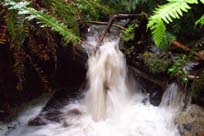
- Blueridge Creek starts north of Hyannis Drive and Berkley Avenue, but is difficult to follow as it is culverted. It flows south through Blueridge Park where it enters another culvert to Derbyshire Way. From Derbyshire, the creek flows south through the Blueridge residential area. South of Mount Seymour Parkway, Blueridge Creek flows through a forested area until it joins McCartney Creek north of Dollarton Highway
- The Blueridge Creek Watershed is bordered by the Seymour River Watershed to the west and the McCartney Creek Watershed to the east
- 55% impervious surface in the McCartney Creek Watershed (GVRD, 1999)
- 55% of the riparian corridor has forest cover (GVRD, 1999)
History
- Before mid-1800’s - North Vancouver District was inhabited by Coast Salish peoples.
- 1860’s - The first significant non-native settlement began.
- 1865 – Hugh Burr puchases land east of Seymour River beginning the first European settlement
- Late 1800’s to early 1900’s – Trees over 90 m high and 11 m in circumference were logged
- Early 1900’s – Accidental introduction of white pine blister rust (Cronartium ribicola) results in the loss of most of the Western white pine on the North Shore
- 1925 - Completion of 2nd Narrows Bridge
- Late 1940’s – Balsam woody aphid (Chermes piceae) introduced which impacts Amabilis firs
- 1960 - Completion of most recent Second Narrows Bridge. Seymour Heights and Windsor Park developed followed by Windsor Park South and Blueridge residential communities
Watershed Use
- Fish: Coho Salmon and Cutthroat Trout
- Wildlife: besides providing habitat for various species, the riparian corridor serves as a travel corridor. Likely species include: shrews, moles, weasels, bobcat, lynx, deer, fox, raccoon, otter, hares, coyote and bear, but no wildlife studies have been conducted
- Bird species observed along Creek corridor during spring 2001 assessment include: Winter Wren (including juvenile), Varied Thrush (including juvenile), Swainson’s Thrush, Northwestern Crow, American Robin, Dark-eyed Junco, American Robin and Hermit Thrush (NSSK, 2001)
- Vegetation: Coastal Western Hemlock, dry subzone. Remaining native trees in watershed include western hemlock, douglas-fir, western red cedar, big leaf maple, and red alder up to about 120 years old.
- Parks: Trillium Park, Blueridge Park
- Residential: the area around the upper reaches of Blueridge is primarily residential
- Schools: Seymour Heights Elementary, Blueridge Elementary
- Commercial: Gas station (Chevron)
- District of North Vancouver: Ron Andrews Community centre and Blueridge Ice Rink
Concerns
- Watershed Health defined as poor due to present development and stormwater management practices (GVRD, 1999)
- Urbanization in the watershed has significantly affected the stream basin. Blueridge has been highly impacted by housing developments in its upper reaches. Problems include extensive dumping of yard clippings and other debris, armouring of the creek banks, and incidence of alien plant species (NSSK, 2001)
- 55% impervious surface in the McCartney Creek Watershed (GVRD, 1999)
- 29 storm drains flow into Blueridge which raises great concerns about the effect of stromwater discharge into a small stream ecosystem including water quality, erosion, and flooding
- There is a lot of trash around Blueridge Creek near the Chevron Gas Station and the Ron Andrews Community centre and Blueridge Ice Rink
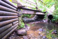
- There are a number of local ‘constructions’ in the creek that are detrimental to creek health (NSSK, 2001)
- Maplewood-Lynnmour area – high level of air pollution (GVRD ambient air monitoring).
Key Interest Groups/Government Bodies
- Municipal Gov’t: District of North Vancouver (DNV); District Parks Department
- Regional Gov’t: GVRD (regional parks, sewers and air quality); GVWD
- Provincial Gov’t: Ministry of Transportation and Highways; Ministry of Environment, Lands and Parks
- Federal Gov’t: Department of Fisheries and Oceans; Environment Canada; Transport Canada
- Local NGO’s: North Shore Streamkeepers; North Shore Fish and Game Club; Pacific Streamkeepers Federation; Blueridge Community Association
- BC Hydro
- School District 44
- North Shore Historical Society
Watershed Projects
Recommendations and Suggested Actions
- Blueridge Creek should not be disturbed if Berkeley Avenue is extended southward to connect with Dollarton Highway ( R.A. Spence, 1979)
- The riparian area around the Blueridge Ice Rink and Ron Andrews Recreation Centre should be replanted to decrease the erosion and protect the creek. Existing riparian should be protected. Also, there are large amounts of trash around the creek in this area (NSSK, 2001)
- Replanting the riparian beside Seymour Heights Elementary School would decrease soil compaction and run-off and provide protection for the creek
Available Sources of Information
BC Ministry of Environment, Lands and Parks. TRIM/UTM Maps
Map: District of North Vancouver
Bouton, Cherry. (2000). North Shore History. www.cherrybouton.com/nshistory.html
Canada: Department of the Environment. (August 1971). "The Burrard Inlet-Howe Sound Area: Preliminary Prescription of Existing Environmental Conditions. Draft Report."
Department of Fisheries and Oceans. (1989). Stream Summary Catalogue.
District of North Vancouver. (2001). GIS Database. North Vancouver: District of North Vancouver.
District of North Vancouver. Seymour Official Community Plan.
District of North Vancouver. Storm Drain Maps. Map Pages: L-08, L-07, L-06, M-06, L-05, M-04
GVRD. (August 1999). Assessment of Current and Future GVS&DD Area Watershed and Catchment Conditions. Prepared for: Liquid Waste Management Plan. Stormwater Management Technical Advisory Task Group.
Kahrer, Gabrielle. (1989). From Speculative to Spectacular: The Seymour River Valley 1870’s to 1980’s: A History of Resource Use. (GVRD Parks Department).
North Shore Streamkeepers. (Spring 2001). Preliminary Watershed Assessments of 12 North Shore Creeks. Unpubl.
Precision Identification Biological Consultants. (1997). Prepared for Fraser River Action Plan, Fisheries and Oceans Branch. Wild, Threatened, Endangered and Lost Streams of the Lower Fraser Valley: Summary Report. Lower Fraser Valley Stream Review, Vol. 1 & 3.
R.A. Spence Engineering Inc. (August 1979). Geotechnical Considerations for Planning of Indian River, Winridge and Maplewood Community Areas.
Stevens, Victoria and A. Eriksson. "Current Trends Along the Lower Fraser River". Government of Canada. Vancouver, 1997.
Tera Environmental Consultants Ltd. (October 1989). Biophysical Inventory and Sensitivity Analysis for the Seymour-Lynn Inter-river lands. Prepared for the District of North Vancouver.
Tera Planning Ltd. (1991). Environmental Assessment of Seymour Youth center.
Water Licenses: http://www.elp.gov.bc.ca:8000/pls/wtrwhse/water_licences.input