Characteristics:
- Third largest watershed in West Vancouver
- Discharges into Capilano River just upstream of Marine Drive
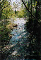
- Originates on southeast side of Hollyburn Ridge, enters British Properties at the northwest corner
- Bordered by Vinson Creek and Lawson Creek watershed to the west and Hadden Creek watershed to the east
- Main tributaries: West Brothers Creek, Hadden Creek in urban area, above 610 m small east branch leads to Lost Lake (765 m), further upstream west branch leads to West Lake (855 m)
- Lakes: Elveden Lake in British Properties, West Lake and Lost Lake plus unnamed lakes and wetlands in headwaters
- Watershed developed to current upper limit of 366 m at Millstream Road, 50% of total watershed is developed
- Total impervious area over lower Brothers Creek catchment is 42%, over upper Brothers Creek-Hadden Creek watershed is 18%
History:
- Originally known locally as Sisters Creek. Confusion with other major Capilano tributary of the same name resulted in change.
- Used as water supply from July 1916. Intake at lot 1101 (213 m elevation) supplemented by the GVWD water main (connected in 1919) at the end of the Keith Road bridge over the Capilano River. The main supply passed down 11th Avenue to Marine Drive. There were 6" headers to Queens, Mathers, Inglewood and Esquimalt Avenues
- West Lake used as water supply for the cabin area
- Hollyburn Ridge ski area and municipal cabin since the 1920’s
- Upstream spawning area restricted by highway construction in 1972 till remediation in 1998
Watershed Use:
- Residential
- Commercial: Capilano Golf Course on Hadden Creek, Hollyburn Winter Club between main and west arm of Brothers Creek, Hollyburn Ridge Nordic ski area in headwaters
- Recreational: Hollyburn Ridge cross country ski area, Trans Canada trail, Baden Powel trail, other trails, mountain biking
- Park: Cypress Provincial Park, Chartwell Park
- Cedardale Elementary School, Westcot Elementary School
- Fish:
- Chinook
- Chum
- Coho
- Pink, spawn below Taylor Way
- Cutthroat trout
- Rainbow
- Steelhead
- Wildlife: diverse populations of mammal, bird and amphibian inhabit the watershed (ie. black bear, otter, great blue heron, kingfisher, American Dipper, Tailed Frog, Ensatina, Western Red Backed Salamander)
- Several residential road crossings, Upper Level Highway, hydro lines
Concerns:
- Classified as endangered by Fisheries and Oceans Canada due to the effects of urbanization such as channelization and large amount of impermeable areas
- Morphology:
- channelization of creek and loss of tributaries through urban area
- bedrock chute 600 metres upstream of highway 1 at Southborough Road
- Water quality:
- altered through proximity to urban development and storm drain discharge
- sanitary sewer lines cross creek in approximately 15 places- potential for leakages
- Creek has problem with human predation of fish
- Future urban development, infill development and possible future expansion of commercial Nordic ski area in upper watershed, and associated problems, including:
- increase in imperviousness
- loss of wetlands and tributaries
- construction of storm drain network resulting in altered water quality and quantity
- encroachment into riparian zones
- tributary channelization, bank alteration
- increased erosion into creek
Key Interest Groups:
- West Vancouver Streamkeepers
- Federal: Department of Fisheries and Oceans
- Provincial: Ministry of Transportation and Highways; Ministry of Environment Lands and Parks
- District of West Vancouver, District Parks Department
- British Properties Area Homeowners Association
- School district 45: Westcot Elementary School, Cedardale Elementary School
- Hollyburn Country Club
- Capilano Golf and Country Club
- British Pacific Properties
- Cypress Bowl Recreation
- B.C. Hydro
- Local churches
Watershed Projects:
- Spawner surveys, 1997 to present
- Water quality sampling, North Shore Streamkeepers, 1999
- Drainage system inventory, McElhanney Consulting Services Ltd., 1998
- Side channel dug, Fisheries and Oceans Canada, 1998
- Westcot pond and fishway constructed, Fisheries and Oceans Canada, 1998
- Fishway installed, habitat improvement, West Brothers Creek, West Vancouver Streamkeepers, 1998
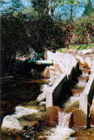
- Creek restoration, baffles installed in culvert, culvert entrance modified, Hadden Creek, British Pacific Properties Ltd, 1997
- Juvenile fish ladder constructed, bank planting, McBeth Tributary, West Vancouver Streamkeepers, 1997
- Fishway constructed in culvert under Wildwood Lane, Brothers Creek, District of West Vancouver engineering department, 1997
- Environmental study of Brothers, West Brothers and Hadden Creeks, BCIT study, 1997
- Biophysical inventory and assessment, Coast River Environmental Services Ltd., 1994
- Stocking of cutthroat trout & steelhead, 1985
- Biophysical inventory, Ministry of Environment, 1980
- Biophysical surveys, 1984-1992
- Timber bolted in herringbone pattern under Upper Levels Highway and Taylor Way, 1977
Recommendations:
- Placement of large woody debris and weir boulders in the lower reaches of West Brothers branch to improve instream cover and pool habitat
- Removal of concrete in the Hadden Creek streambed upstream of the Upper Levels Highway
- Disposal of garbage on stretches of Brothers and Hadden Creeks
- Planting of native vegetation in denuded stream banks
- Regular monitoring of sewage and water lines in and around the creek and periodic coliform sampling
- Monitoring of construction in the British Properties as well as below the highway to protect riparian areas from degradation and sediment input
- Improved communication to increase awareness and foster stewardship of the creek among neighbours
- Maintenance of regular contract with government staff, Streamkeepers and other stakeholders
Available Sources of Information:
- Maps: TRIM/UTM 92G035
Web Sites:
- http://www.pskf.ca The Pacific Streamkeepers Federation
- www.bcfisheries.gov.bc.ca/fishinv/fiss.html Fisheries Information Summary System (FISS)
- www.bcfisheries.gov.bc.ca/fishinv/index.html includes FISS, Survey Data, Base Maps, Methods
- http://www-heb.pac.dfo-mpo.gc.ca/English/maps.htm includes Fish Wizard, Fisheries Project Registry, SHIM Data with Orthophotos, Wild Threatened, Endangered and Lost Streams of the Lower Fraser Valley
- www.shim.bc.ca Sensitive Habitat Information and Mapping
Reports:
- District of West Vancouver Task Force Inquiry into Drainage Policies and Problems. Working Paper #3 Brothers Creek. 1977
- District of West Vancouver Drainage Survey. Dayton and Knight ltd, 1973
- Assessment of Current and Future GVS&DD Area Watershed and Catchment Conditions. Greater Vancouver Sewerage and Drainage District, 1999
- Creeks in West Vancouver. Hugh Johnston?, 1990
- West Vancouver Water Supply. Muckleston, H.B., 1930
- A Place of Excellence; A Chronicle of West Vancouver 1912- 1987. Ramsey, B., 1986
- Lower Fraser Valley Stream Review, Vol. 1. Fisheries and Oceans Canada. Fraser River Action Plan, 1999
- Wild Threatened, Endangered and lost Streams of the Lower Fraser Valley, Summary Report. Fisheries and Oceans Canada. Fraser River Action Plan, 1997
- North Shore Streams- Nutrient Impacts. North Shore Streamkeepers, 1999
- Cypress Provincial Park Hydrology Study and Master Drainage Plan. McElhanney Consulting Services Ltd., 1998
- Summary of 1998 Activities. West Vancouver Streamkeepers, 1998
- Revitalizing West Vancouver’s Major Remaining Salmon Stream. Brothers Creek Task Committee, 1998
- A Habitat Study of Brothers Creek and its Major Tributaries. Goody, K. and Schroeder, G., 1997
- Survey of Biophysical Features Fish Habitat and Enhancement Opportunities in Brothers Creek, West Vancouver, B.C. Coast River Environmental Services Ltd, 1994
- Anadromous Trout Production of Brothers Creek. Ministry of Environment, 1980
- Post Construction Monitoring Report- Sanitary Sewer Installation Across Brothers Creek, 1340 Taylor Way, West Vancouver. Coast River Environmental Services Ltd., 1997
- Selection of Control Rivers for the Cheakamus River Monitoring Program: A Comparative Analysis based on Time Series of Salmon and Steelhead Abundance Indices. 1995