Characteristics
- This watershed includes Noble Creek, Ottley Creek, and part of Chineside Park. It is bounded by the District of Coquitlam to the South and Burrard Inlet to the North.
- Source is the Chines Hillside in Coquitlam.
- Riparian forested ecosystem. The mouth of Schoolhouse Creek South forms a large wetland, including tidal waters and a low estuarine marsh. Wetland area is approximately 19 ha.
- Flood conditions occur regularly, filling the channel to bankfull stage. Has contributed to overall bank stability.
History
- The reach below the Barnett Highway was relocated in 1978.
Watershed Use
- Ownership: City of Port Moody, Various industrial and residential owners.
- Landuse: Commercial, Industrial, Institutional, Parks and Recreation, Residential, CP Right of Way.
- Fish: Chum and Coho Salmon; rainbow, Coastal Cutthroat, Rainbow and Cutthroat Trout.
- Vegetation: Douglas fir/Western hemlock ľ salal; Douglas fir ľSwordfern; Western redcedar ľ foamflower; Sitka spruce - Salmonberry
Concerns
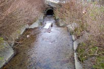
- Mainstem may not be passable to anadromous fish above Clarke St. at all flows, and migration may be restricted at low flows downstream of Andres Wines Ltd. The culvert at Pacific Coast Terminals may cause a delay in migration due to its length (80 m).
- This drainage is almost completely developed and all storm sewers in the drainage are directed into the creek, resulting in flashy conditions of extreme peak flows (several orders of magnitude larger than low flows)
- Minimum flow requirements have been determined to be adequate at all times to meet minimum flow requirements for salmonids.
- Industrial and storm sewer discharges are of concern relative to their impact on water quality in this creek.
- Spawning habitat is not abundant.
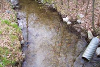
- Limited riparian vegetation in several sections may be limiting to salmonids carrying capacity.
- Creek has been degraded due to encroachments, poor water quality and removal of riparian vegetation.
- Escarpment south of Senior Secondary School has unstable slopes which have slumped and eroded
- A great deal of the watershed has been developed for commercial and industrial uses.
- A Denil fishway located below the downstream side of the St. Johns Street culvert. Between St. Johns and Burrard Inlet, there has been severe disturbance of the creek by industrial development and the CP Rail Right of Way.
Key Interest Groups/Government Bodies
- Municipal Govĺt: City of Coquitlam, City of Port Moody
- Regional Govĺt: GVRD, Vancouver Port Authority
- Provincial Govĺt: Ministry of Environment, Lands and Parks
- Federal Govĺt: Department of fisheries and Oceans
- Local NGOĺs: Port Moody Ecological Society
- Other Stakeholders: Andres Wines, Pacific Coast Terminals, CP Railway
Watershed Projects
- Not known at this time.
Available Sources of Information
City of Port Moody
City of Coquitlam
Port Moody Public Library
Port Moody Ecological Society Library
References
Dunster & Associates Environmental Consultants Ltd., and AXYS Environmental Consulting Ltd. 1999. Port Moody Environmentally Sensitive Areas Management Strategy. Phase 1: An Inventory of Natural Areas. Prepared for the City of Port Moody.
ECL Envirowest Consultants Ltd. 1990. An Assessment of Enhancement Opportunities in Schoolhouse Creek and Suter Brook, Port Moody B.C. Prepared for the City of Port Moody.
Fish Wizard. 2001. Schoolhouse Creek Stream Report. Online: http://
Fraser River Action Plan. 1999. Lower Fraser Valley Streams (Vol.1): Strategic Review. Queens Printer. ISBN 0-662-26167-4
Furber, K. 1996. Stream Survey of South Schoolhouse Creek. Prepared for BCIT Fish Wildlife and Recreation Program.
Precision Identification Biological Consultants. 1997. Lower Fraser Valley Stream Review (Vol. 3): Wild, Threatened, Endangered and Lost Streams of the Lower Fraser Valley. Prepared for Fraser River Action Plan. Queens Printer. ISBN 0-662-26029-5