Characteristics
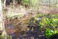
- Parkside Creek originates in the forested area on lower Mount Seymour. It is a small, low gradient groundwater fed system. The middle reaches are located on Indian River benchland which has some development, while the lower reaches in Deep Cove are significantly developed. The creek flows into Deep Cove in Burrard Inlet at Cove Cliff.
- Status: Threatened – Portions of Parkside Creek have been culverted and channelized, and the creek has water quality problems
- Trend: Stable
- 19% impervious surface area in catchment (GVRD, 1999)
History
- Deep Cove was a popular food gathering place for people of the Tsleil’watututh Nation
- 1860’s - The first significant non-native settlement began.
- Late 1880’s– Logging began
- 1907 – Clusters of cottages were built along the waterfront at Deep Cove and Cove Cliff
- 1918 – Deep Cove Logging Co. began operations
- 1926 – Timber limits exhausted
- 1950’s–1970’s – Residential development increased
- Where was the farmhouse?
Watershed Use
- Parkside is 1 of 2 fish bearing streams in Deep Cove. Anadromous fish have access for about a kilometer up to an impassible culvert at Cove Cliff Road (DFO, 1998). Coho have been found downstream of Banbury Road; cutthroat upstream
- The estuary is an important area for groundfish and marine animals (Waterfront, 1995)
- Wildlife: 83 bird species and 16 mammal species expected (Environmental, 1974). Red-tailed and sparrow hawks, ruffed grouse, dusky shrew, deer, bear and raccoon
- Coastal Western Hemlock Zone (Drier Subzone) transition to Coastal Douglas-fir Zone (Environmental, 1974)
- The creek is surrounded by residential development in the Cove Cliff neighbourhood
- Recreational: walking, dog-walking
- Cove Cliff Elementary School
- Parks include Parkside Park and Deep Cove Park
- Deep Cove Boat Rentals
- Sanitary Pump Station
Concerns
- Stream has been classified as endangered due to impacts (FRAP)
- Significant loss of riparian vegetation along more than 50% of the fish frequented length of the stream (FRAP)
- Significant water quality problems (FRAP):
- 11stormwater outlets affect water quality and quantity via street runoff and storm events
- Deep Cove has high faecal coliform bacteria counts particularly in summer months (Waterfront, 1995)
- Parkside was heavily impacted by a sewerage spill in 1994 (Waterfront, 1995)
- The estuary is an important area for groundfish and marine animals (Waterfront, 1995)
- Heavy urbanization has significantly affected the stream basin (FRAP)
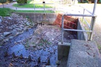
- Channelization, armourization, or dyking of over 50% of the fish frequented length of the stream (FRAP). Significant sections of the creek have been culverted (DFO, 1998)
- Progressive sedimentation and plugging of trash racks at culvert inlets under flood flow conditions
- Fish passage through the culvert off Felix Cres. would be difficult; culvert on Indian Arm Rd. is likely impassable
Key Interest Groups/Government Bodies
- Municipal Gov’t: District of North Vancouver (DNV); District Parks Department
- Regional: GVRD (regional parks, sewers and air quality); GVWD
- Provincial Gov’t: Ministry of Transportation and Highways; Ministry of Environment, Lands and Parks; Burrard Inlet Environmental Action Program
- Federal Gov’t: Department of Fisheries and Oceans; Environment Canada; Transport Canada
- Local NGO’s: North Shore Streamkeepers; North Shore Fish and Game Club
- School District 44: Cove Cliff Elementary School
- Deep Cove Historical Society
- North (Shore/Vancouver) Historical Society
Watershed Projects
- Several restoration/enhancement projects have been completed in the system by Cove Cliff Elementary school working with the District of North Vancouver. Projects have included construction of a side channel, incubation boxes, and stream cleanups
- 1997 – GIS mapping - District of North Vancouver
Recommendations and Suggested Actions
Construction of a fishway at the mouth of the creek is proposed as the system is only accessible to anadromous fish at high tide (DFO, 1998)
Stewardship initiatives concentrating on improving water quality, preventing encroachments into the channel and floodplain, storm drain marking, signage and access management, landowner contact, and increasing public awareness are needed (DFO, 1998)
The District of North Vancouver should be encouraged to maintain, and possibly expand, its comprehensive Environmental and Preservation Bylaw which protects, preserves, and conserves natural settings and ecological systems of trees, watercourses, soils and lands (DFO, 1998)
Particular attention should be paid to the disposal of stormwater when planning development (Environmental Research Consultants Ltd.,1974)
Future enhancement: installing a fishway in the culvert at Banbury Rd.
Available Sources of Information
Maps: TRIM/UTM 92G036 - BC Ministry of Environment, Lands and Parks
Map: District of North Vancouver
Brooke, Robert C. and Kojima, Satoru. Vegetation Survey, North Vancouver, Deep Cove.
Council of the District of North Vancouver. (December 1977). The Development of Seymour.
District of North Vancouver Stream Survey Cards. (1993).
Environmental Research Consultants Ltd. (1974). Landscape Reconnaissance: Deep Cove. The Corporation of the District of North Vancouver.
EVS Consultants and the District of North Vancouver. (March 1989). Deep Cove Water Quality Investigation.
Precision Identification Biological Consultants. (1997). Prepared for Fraser River Action Plan, Fisheries and Oceans Branch. Wild, Threatened, Endangered and Lost Streams of the Lower Fraser Valley: Summary Report. Lower Fraser Valley Stream Review, Vols. 1 & 3.
Kerr Wood Leidal Associates Ltd. (1999) "Overview Study of Debris Flow Hazards". Prepared for the District of North Vancouver.
Kerr Wood Leidal Associates for the District of North Vancouver. (July 1982). "Report on Creek Systems and Stormwater Control".
Nells, S. (1978). Comments on Juvenile Salmonid Utilization of Burrard Inlet and Vancouver Harbour. Dept. of Fisheries and Oceans, Vancouver, B.C.
Smith, G.M. (1989). Covecliff School Fisheries Impact Assessment and Recommendations for Impact Compensation of Myrtle Creek. North Vancouver School District No. 44.
Waterfront Task Force (June 1995). Deep Cover to Dollarton Waterfront: Planning for the Future. Corporation of District of North Vancouver.