Characteristics
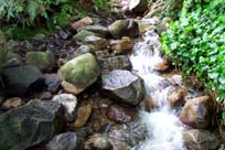
- Kilmer Creek originates on the east slope of Grouse Mountain. The Creek flow through the forested slopes until it reachs East Braemar and Demsey Roads where it flows southeast through a residential area to Wellington Drive. Kilmer Creek is culverted from Wellington Drive to where it enters Hastings Creek
- Kilmer Creek Watershed is bordered by Dyer Creek Watershed to the west and Coleman Creek Watershed to the east
- Kilmer flows range from an estimated high of 18 cubic feet/second in January to a low of 1.4 cubic feet/second in August. Historical values for flow levels are not available (Eikos Design Group, 1978)
- 21% impervious surface in the Hastings Creek Watershed (GVRD, 1999)
- 54% of the Hastings Creek Watershed had forest cover (GVRD, 1999)
History
- 1860’s - The first significant non-native settlement began as the Douglas-fir and Western white pine were cut for spars or sailing ship masts and exported to Britain for Royal Navy ships. Lynn Valley became known as spar forest as it provided spars 70 feet long and 13 feet in diameter
- 1875 – Logging for red cedar bolts became the main activity
- 1899 - First home in Lynn Valley built by J.M. Fromme in a clearing from the logging (Eikos Design Group, 1978) (Draycott, W. M., 1919)
- Early 1900’s – Accidental introduction of white pine blister rust (Cronartium ribicola) results in the loss of most of the Western white pine on the North Shore
- 1903 – Fromme subdivides his lot selling 60 blocks at $25 per acre
- 1904 – 1st school opens on May 20th
- Lynn Valley Population: 1909=200; 1919=1,400; 1971=25,000
- Kilmer Flood Events: 1909, 1914, 1919, 1933, 1949, 1955, 1958, 1961 (3 floods), 1968 (Resource Analysis Branch, MOE, 1977)
- Late 1940’s – Balsam woody aphid (Chermes piceae) is introduced affecting the Amabilis fir
- Early 1960's - Culvert installed at Hoskins Road stops salmon from reaching spawning grounds in Kilmer, Thames, Hoskins, and Pierard (Eikos Design Group, 1978)
Concerns
- Kilmer Creek is in a culvert from its confluence with Hastings, underneath Argyle Secondary School, and not daylighting until the north side of Frederick Road. As a length of 60 m or more, this culvert is a barrier to fish movement
- Residential development in the creek's upper reaches appears to have had a very detrimental effect on creek health and populations
- Upper Kilmer Creek basin is a shallow, unconfined channel on a steep slope formed over compact till - tends to become unstable at high flows (Resource Analysis Branch, MOE, 1977)
- 5 storm drains flow into Kilmer Creek
- Watershed vulnerable to critical peak flow increases (Resource Analysis Branch, MOE, 1977)
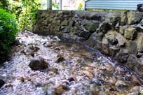
- The Kilmer Cutoff, constructed to prevent flooding below Kilmer Road, subsequently alters the peak flows by intercepting tributaries and directing the overflow into Lynn Creek (Eikos Design Group, 1978)
- Urbanization generally causes an increase in total runoff and high flows and a reduction in low flows accentuating the flash nature of the creek (Eikos Design Group, 1978)
- There is a 5 m high dam on Kilmer Creek that was constructed approximately 30 years ago. It is a barrier to fish passage and has had a substantial impact on the stream
- 21% impervious area in watershed (GVRD, 1999)
- Kilmer Creek is suffering from various problems associated with urban development including an increase in impervious surfaces, riparian removal, channelization of the creek and bank alteration (NSSK, 2001)
Watershed Use
- Fish: Cutthroat Trout and Steelhead
- Cutthroat found above and below Wellington Drive and above Fromme Road in the 1993 Fish Trapping Survey (District of North Vancouver, 1993)
- Occasional coho fry found during electoshocking. May have come from local school involved in the Salmon Enhancement Program (Methven, 1987)
- Coho noted above Chamberlain Drive (Nells, 1978)
- Steelhead noted upstream of Frederick Road (Min. of the Env., 1976)
- Wildlife: Various species including raccoons, mink, river otters, black bears, Belted Kingfishers, Dippers, Great Blue Herons, Common Mergansers, Harlequin Ducks, and Swallows (Tera Environmental Consultants Ltd.)
- Bird species observed during assessment in spring 2001: Swainson's thrush, Golden-crowned kinglet, American robin, Black-capped chickadee (NSSK, 2001)
- Vegetation: Coastal Western Hemlock, dry subzone. Remaining native trees in watershed include western hemlock, douglas-fir, western red cedar, big leaf maple, and red alder up to about 120 years old
- Schools: Fromme Elementary School
- Trails: Walking, dog-walking
- Residential: the lower half of Kilmer Creek runs through an area that is primarily residential
Key Interest Groups/Government Bodies
- Municipal Gov’t: District of North Vancouver (DNV); District Parks Department
- Regional Gov’t: GVRD (regional parks, sewers and air quality); GVWD
- Provincial Gov’t: Ministry of Transportation and Highways; Ministry of Environment, Lands and Parks
- Federal Gov’t: Department of Fisheries and Oceans; Environment Canada; Transport Canada
- Local NGO’s: North Shore Streamkeepers; North Shore Fish and Game Club; Pacific Streamkeepers Federation; Lynn Valley Community Association
- BC Hydro
- School District 44
- North (Shore/Vancouver) Historical Society
Watershed Projects
- 1992 - 500 Coho fry released in Kilmer Creek at Fromme Road
- 1993 - 250 Coho fry released into Kilmer by students of Boundary School
Recommendations and Suggested Actions
- Preservation of greenbelts adjacent to watercourses is recommended for prevention of flooding problems and preservation of community values (Resource Analysis Branch, MOE, 1977)
- The success of enhancement programs require maintenance of water quality, provision for adequate minimum summer flow levels, and maintenance of essential stream characteristics including pool and riffle development, gravelly bouldery stream beds, and minor lateral erosion. The effect on these factors of additional development in the upper Hastings basin must be carefully evaluated (Eikos Design Group, 1978)
- DNV has considered putting a lighted walkway along the creek near Sauve Place. As Kilmer Creek has been highly impacted by development and this riparian area is potentially important as wildlife habitat, an impact assessment of the trail should be conducted before proceeding (NSSK, 2001)
Bibliography and Available Sources of Information
BC Ministry of Environment, Lands and Parks. TRIM/UTM Maps
Bouton, Cherry. (2000). North Shore History. www.cherrybouton.com/nshistory.html
Canada: Department of the Environment. (August 1971). "The Burrard Inlet-Howe Sound Area: Preliminary Prescription of Existing Environmental Conditions. Draft Report."
Clark, B. (1985). Hastings Creek Habitat Evaluation. MoE: Fish and Wildlife Branch. Surrey, B.C.
Department of Fisheries and Oceans. (1989). Stream Summary Catalogue.
District of North Vancouver Fish Trapping Summary. (1993). Unpubl.
District of North Vancouver. (2001). GIS Database.
District of North Vancouver. Lynn Valley Official Community Plan.
District of North Vancouver. Storm Drain Maps. Map Pages: H-13, H-12, H-11, I-11.
District of North Vancouver Website. (2001). Hastings Creek Salmon Restoration Update. www.district.north-van.bc.ca/admin2/depart/enviro/hastings%5Fcreek %5Fupdate.html
Draycot, Walter. (1912). "Lynn Valley: From the Wilds of Nature to Civilization". North Vancouver.
Draycot, Walter. (February 2000). Early Days in Lynn Valley. North Vancouver, BC: Contact Printing and Mailing Ltd.
Eikos Design Group. (1978). "Lynn Valley Environmental Analysis: A Technical Overview Report."
Gabby. "Logging History of the North Shore". (1994). North Vancouver: Lynn Canyon Ecology Centre Library.
GVRD. (August 1999). Assessment of Current and Future GVS&DD Area Watershed and Catchment Conditions. Prepared for: Liquid Waste Management Plan. Stormwater Management Technical Advisory Task Group.
The Lynn-Seymour Rivers and the Hastings Stream: Geologic History of Their Origin.
Ministry of the Environment. (1976). Fisheries Habitat Surveys. MOE: Fish and Wildlife Branch. Surrey, BC.
Maynard, Denny. (1977). Guidebook for Geologic Field Trips in the Lynn Canyon-Seymour Area of North Vancouver. Dept. of Geologic Science, UBC.
Methven, Sharon. (1987). "Bio-Physical Survey of Lower Lynn Creek and Tributaries". North Vancouver: Lynnmour Community School Association.
Nells, S. (1978). Comments on Juvenile Salmonid Utilization of Burrard Inlet and Vancouver Harbour. Department of Fisheries and Oceans. Vancouver, BC.
North Shore Streamkeepers. (Spring 2001). Preliminary Watershed Assessments of 12 North Shore Creeks. Unpublished.
Precision Identification Biological Consultants. (1997). Prepared for Fraser River Action Plan, Fisheries and Oceans Branch. Wild, Threatened, Endangered and Lost Streams of the Lower Fraser Valley: Summary Report. Lower Fraser Valley Stream Review, Vol. 1 & 3.
Resource Analysis Branch, Ministry of the Environment. (1977). "Resource Analysis For Urban Suitability: Vancouver's Northshore Area."
Steward, Barry. "Lynn Valley’s Creeks and Fish Habitats". (1975). North Vancouver: Lynn Canyon Ecology Centre. (North Shore Archives).
Tera Environmental Consultants Ltd. Seymour-Lynn Vegetation and Wildlife Species List.
Water Licenses: http://www.elp.gov.bc.ca:8000/pls/wtrwhse/water_licences.input