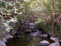
Characteristics
- Keith Creek begins north of Lynn Valley Road and flows southeast through residential area. Keith Creek enters the City of North Vancouver just before it flows beneath the Upper Levels Highway. Keith is culverted for a long section in the City and then daylights to flow through a park area. Keith re-enters the District of North Vancouver and is crossed by the Upper Levels Highway twice more before flowing into Lynn Creek just north of Keith Road and west of Mountain Hwy
- In spite of being highly impacted by urban development, Keith Creek continues to support life: the creek that just wouldn’t quit!
- Bordered by the Wagg Creek Watershed (Mosquito Creek) to the west, the Lynn Creek Watershed to the east and the Hastings Creek Watershed to the north
- Status: Endangered – due to riparian removal, urbanization, culverting and degraded water quality (FRAP)
- Watershed Health defined as fair declining to poor due to present development and stormwater management practices (GVRD, 1999)
- 47% of the riparian corridor has forest cover (GVRD, 1999)
- 21% impervious area in watershed (GVRD, 1999)
- Reach 1 of Keith Creek (from the mouth to the Upper Levels Highway bridge to the flood channel and culvert barrier at Mountain Highway) has characteristics which make it prime habitat for juvenile coho salmon (Methven, 1987):
- an average depth of .42 m
- a velocity of .28 m/sec
- cobble comprising 20% of the sustrate
- .8% of the total pool area has undercut banks
History
- Keith Creek was named after W. J. Keith who was a land developer
- Before mid-1800’s -North Vancouver District was inhabited by Coast Salish peoples.
- Early 1900’s – Accidental introduction of white pine blister rust (Cronartium ribicola) results in the loss of most of the Western white pine on the North Shore
- Flood events: 1921, 1960, 1968, 1972
- Late 1940’s – Balsam woody aphid (Chermes piceae) is introduced impacting the Amabilis fir
Watershed Use
- Fish: Coho Salmon, Cutthroat Trout, Sculpin and Steelhead
- Cutthroat observed during assessment in spring 2001 (NSSK, 2001)
- 4 rainbow trout and 13 sculpin found below Mountain Highway and steelhead observed upstream of lower Trans-Canada culvert in 1993 Fish Trapping Survey. Also, 3 cutthroat found below 21st St., 1 above Calverhall, 2 below 14th St. and 1 above Mountain Highway (District of North Vancouver, 1993)
- Bio-physical survey found a large number of coho in Reach 1 (from the mouth to the Upper Levels Highway bridge to the flood channel and culvert barrier at Mountain Highway). Survey found that Reach 1 had ideal rearing pool habitat for coho salmon (Methven, 1987)
- Wildlife: – besides providing habitat for various species, the riparian corridor serves as a travel corridor. Likely species include: shrews, moles, weasels, bobcat, lynx, deer, fox, raccoon, otter, hares, coyote, but no wildlife studies have been conducted
- Bird species observed during preliminary assessment in spring 2001 include Mallards, Cedar Waxwing, Swainson’s Thrush, Stellar’s Jay, Golden-crowned Kinglet, Winter wren and Ruby-crowned Kinglet
- Crayfish noted in the creek (NSSK, 2001)
- Vegetation: - Coastal Western Hemlock, dry subzone. Remaining native trees in watershed include western hemlock, douglas-fir, western red cedar, big leaf maple.
- Parks: Loutet Park; Lynn Canyon Park; Keith Lynn Park; Bridgeman Park
- Schools: Keith-Lynn Elementary School; Boundary School; Sutherland High School
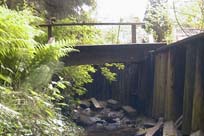
- Highway: Runs alongside and beneath the Trans-Canada Highway
- Residential: Keith Creek flows through residential areas in both the District and City of North Vancouver
- Commercial: Various businesses on Lynn Valley Road including West Lynn Shopping Centre
Concerns
- Stream classified as endangered due to impacts (FRAP)
- Watershed Health defined as fair declining to poor due to present development and stormwater management practices (GVRD, 1999)
- 21% impervious area in watershed (GVRD, 1999)
- Water quality – Significant problems caused by urban development (FRAP). Serious non-point source pollution problem caused by contaminated stormwater being discharged directly into the creek, spills into storm drains, impervious surfaces near the banks and loss of riparian vegetation
- 24 storm drains flow into Keith
- Urbanization in the watershed has significantly affected the stream basin (FRAP)
- Bank and slope stability leading to erosion and flooding. Progressive sedimentation and plugging of trash racks at culvert inlets under flood flow conditions in tributary channels in upper reaches (Kerr Wood Leidal Associates, 1982).
- Extensive culverting including in the City of North Vancouver and under the Upper Levels Highway and Mountain Highway have resulted in barriers for fish migration (Road construction in the 1950’s created impassable culverts, severely reducing the coho runs)
- Keith Creek was diverted when Tempe Heights about 15 impacted resident cutthroat population 15 years ago
Key Interest Groups/Government Bodies
- Municipal Gov’t: District of North Vancouver (DNV); City of North Vancouver; District and City Parks Departments
- Regional Gov’t: GVRD (regional parks, sewers and air quality); GVWD
- Provincial Gov’t: Ministry of Transportation and Highways; Ministry of Environment, Lands and Parks; BC Hydro
- Federal Gov’t: Department of Fisheries and Oceans; Environment Canada; Transport Canada
- Local NGO’s: North Shore Streamkeepers; North Shore Fish and Game Club; Pacific Streamkeepers Federation; Lynn Valley Community Association
- School District 44
- North (Shore/Vancouver) Historical Society
Watershed Projects
- 1992 - Lynnmour School students released 450 fry into Keith Creek above Mountain Highway
- 1993 - Lynnmour School students released 400 fry into Keith Creek above Mountain Highway
- Incubation box installed at the junction of Keith and Lynn Creeks
- Enhancement work was done to create pool-riffle sequence between Keith Road and Upper Levels Highway bridge to the flood channel and culvert barrier at Mountain Highway (Methven, 1987)
Bibliography and Available Sources of Information
BC Ministry of Environment, Lands and Parks. TRIM/UTM Maps
Bell, Kevin. (Fall 1992). Article written for Big Trees of BC.
Bouton, Cherry. (2000). North Shore History. www.cherrybouton.com/nshistory.html
Canada: Department of the Environment. (August 1971). "The Burrard Inlet-Howe Sound Area: Preliminary Prescription of Existing Environmental Conditions. Draft Report."
De Leeum, A.D. and K.M. Stuart. (1981). Resource Atlas for Lower Mainland Sea-run Cutthroat Study. MOE: Fish and Wildlife Branch. Surrey, BC.
Department of Fisheries and Oceans. (1989). Stream Summary Catalogue.
District of North Vancouver Fish Trapping Summary. (1993). Unpubl.
District of North Vancouver. (2001). GIS Database.
District of North Vancouver. Storm Drain Maps. Map Pages: J-05, I-05, I-06, H-06, H-08, H-09, I-08, and I-09
District of North Vancouver. Official Community Plan.
District of North Vancouver. (1974). "Summer Project: A Study of Fish Habitats". North Vancouver: District of North Vancouver.
FRAP "Wild, Threatened, Endangered, and Lost Streams of the Lower Fraser Valley - Summary Report".
Gabby. "Logging History of the North Shore". (1994). North Vancouver: Lynn Canyon Ecology Centre Library.
GVRD. (August 1999). Assessment of Current and Future GVS&DD Area Watershed and Catchment Conditions. Prepared for: Liquid Waste Management Plan. Stormwater Management Technical Advisory Task Group.
Kerr Wood Leidal Associates Ltd. (1999) "Overview Study of Debris Flow Hazards". Prepared for the District of North Vancouver.
Kerr Wood Leidal Associates for the District of North Vancouver. (July 1982). "Report on Creek Systems and Stormwater Control".
The Lynn-Seymour Rivers and the Hastings Stream: Geologic History of Their Origin.
Methven, Sharon. (1987). "Bio-Physical Survey of Lower Lynn Creek and Tributaries". North Vancouver: Lynnmour Community School Association.
North Shore Streamkeepers. (Spring 2001). Preliminary Watershed Assessments of 12 North Shore Creeks. Unpublished.
Precision Identification Biological Consultants. (1997). Prepared for Fraser River Action Plan, Fisheries and Oceans Branch. Wild, Threatened, Endangered and Lost Streams of the Lower Fraser Valley: Summary Report. Lower Fraser Valley Stream Review, Vol. 1 & 3.
Stevens, Victoria and A. Eriksson. "Current Trends Along the Lower Fraser River". Government of Canada. Vancouver, 1997.
Steward, Barry. "Lynn Valley’s Creeks and Fish Habitats". (1975). North Vancouver: Lynn Canyon Ecology Centre. (North Shore Archives).
Water Licenses: http://www.elp.gov.bc.ca:8000/pls/wtrwhse/water_licences.input